Maps of England

England und Wales
Hand-Atlas über alle Theile der Erde nach dem neuesten Zustande und über das Weltgebäude Stieler, Adolf bei Justus Perthes
England
Hand-Atlas über alle Theile der Erde nach dem neuesten Zustande und über das Weltgebäude Stieler, Adolf bei Justus Perthes
England
Stieler's Hand-Atlas Stieler, Adolf bei Justus Perthes
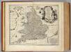
Regni Angliæ nova tabula
1 Karte : Kupferdruck ; 49 x 49, Gesamtgrosse 49 x 58 cm Ottens; Ottens apud R. et I. Ottens
England and Wales.
1 : 2050000 Carey, Mathew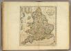
Map of England and Wales.
1 : 2000000 Carey, Mathew
England and Wales.
1 : 1900800 Carey, Mathew
Map Of England and Wales.
1 : 1900800 Carey, Mathew
Map Of England and Wales.
1 : 1900800 Carey, Mathew
ANGLIA | REGNVM.
[Amsterdam : Joan Blaeu]
England & Wales.
1 : 1013760 Stanford, Edward

Le royavme d'Angleterre
1 Karte : Kupferdruck ; 43 x 50 cm, Bildgrösse 43 x 58 cm Nolin; Guérard; Coronelli; Du Tralage; Jean; Mondhare chez Mondhare et Jean rue St. Jean de Beauvais
Le royaume d'Angleterre
1 Karte : Kupferdruck ; 47 x 50 cm Robert de Vaugondy; Santini; Remondini chez Mr. Remondini
Le royaume d'Angleterre
1 Karte : Kupferdruck ; 47 x 50 cm Robert de Vaugondy; Haussard G. et D. Robert de Vaugondy
Regni Angliæ et Walliæ principatus tabula
1 Karte : Kupferdruck ; 49 x 58 cm Gouwen; Tideman I. Covens et C. Mortier
Le royavme d'Angleterre
1 Karte : Kupferdruck ; 43 x 50 cm, Bildgrösse 43 x 58 cm Nolin; Guérard; Coronelli chez I. B. Nolin sur le quay de l'Horloge du Palais proche la rue de Harlay a l'enseigne de la place des Victoires
Anglia regnvm
1 Karte : Kupferdruck ; 37 x 48 cm Janssonius apud Ioannem Ianssonium
Anglia regnvm
1 Karte : Kupferdruck ; 37 x 48 cm Blaeu Joan Blaeu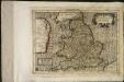
Angliæ regnum
1 Karte : Kupferdruck ; 17 x 24 cm Mercator Joannes van Cloppenburgh
A map of ye south part of Great Britain, called England and Wales, containing all ye cities, market towns, post towns, boroughs: and whatever places have ye election of members of Parliament &c. All the great or post-roads, and principal cross-roads &c. with ye computed miles from town to town
1 : 2200000 by Herman Moll [London], Herman Moll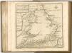
South Britain, or England and Wales.
1 : 2170000 Bowen, Emanuel
Regnum Angliæ, sive pars australis Magnæ Britanniæ
1 Karte : Kupferdruck ; 47 x 58 cm Valck; Valck Gerard und Leonardus Valck
Anglia regnvm
1 Karte : Kupferdruck ; 37 x 48 cm s.n.
England, Ireland.
1 : 3900000 Peterson, Augusts
Anglia, Regnum si quod aliud in toto Oceano ditissimum et florentißimum. [Karte], in: Theatrum orbis terrarum, S. 83.
1 Karte aus Atlas Ortelius, Abraham Vrients, Jan Baptista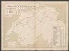
Anglia Regnum [Karte], in: Le théâtre du monde, ou, Nouvel atlas contenant les chartes et descriptions de tous les païs de la terre, Bd. 4, S. 84.
1 Karte aus Atlas Blaeu, Willem Janszoon und Blaeu, Joan Blaeu, Willem Janszoon
Anglia Regnum [Karte], in: Theatrum orbis terrarum, sive, Atlas novus, Bd. 4, S. 106.
1 Karte aus Atlas Blaeu, Joan Blaeu, Willem Janszoon


