Maps of Caucasus Mountains

[Ost-Europa in 6 Blättern, enthaltend: Norwegen, Schweden, Russland, Kaukasien und die Türkei, Blatt 6]
Hand-Atlas über alle Theile der Erde und über das Weltgebäude Stieler, Adolf Justus Perthes
[Ost-Europa in 6 Blättern, Blatt 6]
Handatlas über alle Theile der Erde und über das Weltgebäude Stieler, Adolf Justus Perthes
[Ost-Europa, Blatt 6]
Adolf Stieler's Handatlas über alle Theile der Erde und über das Weltgebäude Stieler, Adolf Justus Perthes
Ost-Europa, No. 6: Sud-Russland & Kaukasien.
1 : 3700000 Petermann, A.
Süd-Russland und Kaukasien
1 : 3500000 Kavkaz-oblast J. Schlacher
Küstenländer des Schwarzen Meeres
1 : 8880000 Černé moře-oblast Renner Kleinknecht
KÜSTENLÄNDER des SCHWARZEN MEERES
1 : 8880000 Černé moře (oblast) Renner Kleinknecht Bibliographisches Institut
Charte der Laender am Caucasus nach den besten vorhandenen
1 : 2100000 Reinecke, J. C. M. (Johann Christoph Matthias), 1770-1818 Im Verlage des Industrie Comptoirs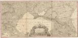
Carte de la partie septentrionale de l'Empire Otoman
1 : 1420000 osmanská říše Rizzi Zannoni, Giovanni Antonio Arrivet
XXXX. Panzerkorps vom 30. 6. bis 30. 9. 1942
1 : 2500000 Kavkaz-oblast Korpskartenstelle
Carte des environs de la Mer-Noire où se trouvent l'Ukrayne, la Petite Tartarie, la Circassie, la G
1 : 2500000 1 Karte auf 2 Blatt : Kupferdruck ; 50 x 92 cm Robert de Vaugondy, Didier chez Delamarche rue du Foin près celle de la Harpe au collége de M.e Gervais
Uebersichts Karte der Russischen Provinzen nördlich und südlich vom Kaukasus
1 : 2500000 München : in der literarisch artistischen Anstalt
Pontus Euxinus et quae adjacent
1 : 4440000 Bospor (Turecko : průliv) Spruner, Karl von Justus Perthes
Uebersichts Karte der russischen Provinzen nördlich und südlich vom Kaukasus
1 : 2900000 1 Karte : Kupferdruck ; 42 x 47 cm in der literarisch artistischen Anstalt
22-23. RSFSR in Europe, South. Georgian SSR, Azerbaijan SSR, Armenian SSR. The World Atlas.
1 : 3000000 USSR (Union of Soviet Socialist Republics).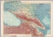
U.S.S.R. - Caucasia. Pergamon World Atlas.
1 : 2500000 Polish Army Topography Service
Die Völker des Kaukasus u.s.w. / gezeichnet u. gestochen in der geogr. Kunstschule zu Potsdam
1 : 2900000 1 Karte : Kupferdruck ; 31 x 39 cm Berghaus, Heinrich Karl Wilhelm J. Perthes
Russia 9.
1 : 3421400 Letts, Son & Co.
Russia in Europe Part IX and Georgia.
1 : 3500000 Society for the Diffusion of Useful Knowledge (Great Britain)
Russia in Europe part IX and Georgia / published under the superintendence of the Society for the Di
1 : 3500000 1 Karte : Kupferdruck ; 31 x 38 cm Walker, John by Baldwin and Cradock
Carte générale du pays entre les mers Noire et Caspienne
1 : 2300000 Kaspické moře-oblast Darmet, J.M. Damas, Ange Hyacinthe Maxence de
Höhenschichtenkarte der Kaukasusländer mit Reiserouten Dr. G. Raddes
1 : 4500000 Radde, Gustav Engelmann
Uebersichts Karte der russischen Provinzen nördlich und südlich vom Kaukasus
1 : 2900000 Kavkaz (pohoří : oblast) Literarisch artistische Anstalt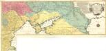
Carte Geographique representant le Théatre de la Guerre entre les Russes les Turcs, et les Polonois Confédérés
1 : 1600000 Mollova mapová sbírka Lotter, Tobias Conrad Lotter, Georg F. Lotter, Tobias Conrad
The Black Sea and surronding countries”
1 mapa. Datat entre 1840 i 1849. Hughes, William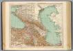
73-74. Caucasia, Mar Caspio.
1 : 3000000 Touring club italiano
Das Deutschtum II. 2.
Schwarzmeer-Gebiet Ethnische Gruppe, Deutsche
Nowaja Semlja zum Gouv. Archangelsk gehörig
1 : 8000000 1 Karte : Lithographie ; 26 x 19 cm Schlieben, W.E.A. von [Georg Joachim Göschen]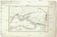
Carte du pourtour septentrional de la Mer Noire
1 : 5000000 Černé moře-oblast Lapie, Pierre Arnoul Firmin Didot
![[Ost-Europa in 6 Blättern, enthaltend: Norwegen, Schweden, Russland, Kaukasien und die Türkei, Blatt 6]](https://images-2.georeferencer.com/images/iiif/868770786454/full/,300/0/native.jpg)

