Maps of Pontic Steppe

Küstenländer des Schwarzen Meeres
1 : 8880000 Černé moře-oblast Renner Kleinknecht
KÜSTENLÄNDER des SCHWARZEN MEERES
1 : 8880000 Černé moře (oblast) Renner Kleinknecht Bibliographisches Institut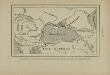
Pénétration et marche des Avars en Europe orientale
Osteuropa Avaren Völkerwanderungszeit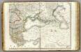
Europe 4.
1 : 3850000 Brue, Adrien Hubert, 1786-1832
Carte de La Russie D'Europe.
1 : 6700000 Vivien de St Martin, L.
Carte des environs de la Mer-Noire où se trouvent l'Ukrayne, la Petite Tartarie, la Circassie, la G
1 : 2500000 1 Karte auf 2 Blatt : Kupferdruck ; 50 x 92 cm Robert de Vaugondy, Didier chez Delamarche rue du Foin près celle de la Harpe au collége de M.e Gervais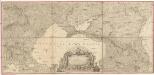
Carte de la partie septentrionale de l'Empire Otoman
1 : 1420000 osmanská říše Rizzi Zannoni, Giovanni Antonio Arrivet
Administrativnaja Karta Evropejskoj časti C.C.C.P.

The Black Sea and surronding countries”
1 mapa. Datat entre 1840 i 1849. Hughes, William
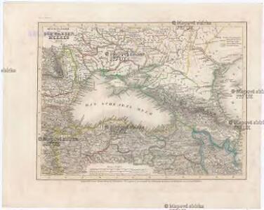
Süd-Russland und Kaukasien
1 : 3500000 Kavkaz-oblast J. Schlacher
Nr. 5. Rußland und Konstantinopel
Schwarzmeer-Gebiet
Grece. Caucase et Crimee.
1 : 2000000 Jouvet et Cie.
Nova et accurata Tartariae europaeae seu minoris et in specie Crimeae delineatio geographica / manu
1 : 2900000 1 Karte : Kupferdruck ; 48 x 56 cm [Matthäus Seutter]
Pontus Euxinus et quae adjacent
1 : 4440000 Bospor (Turecko : průliv) Spruner, Karl von Justus Perthes

[Ost-Europa in 6 Blättern, Blatt 6]
Handatlas über alle Theile der Erde und über das Weltgebäude Stieler, Adolf Justus Perthes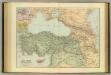
Asia Minor, Caucasus, Black Sea.
1 : 3220177 Stanford, Edward
[Ost-Europa in 6 Blättern, enthaltend: Norwegen, Schweden, Russland, Kaukasien und die Türkei, Blatt 6]
Hand-Atlas über alle Theile der Erde und über das Weltgebäude Stieler, Adolf Justus Perthes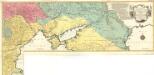
Carte Geographique representant le Théatre de la Guerre entre les Russes les Turcs, et les Polonois Confédérés
1 : 1600000 Mollova mapová sbírka Lotter, Tobias Conrad Lotter, Georg F. Lotter, Tobias Conrad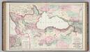
Vicinity of the Black Sea.
1 : 3787000 Gray, Ormando Willis
[Ost-Europa, Blatt 6]
Adolf Stieler's Handatlas über alle Theile der Erde und über das Weltgebäude Stieler, Adolf Justus Perthes
Nouvelle carte de la petite Tartarie ou Taurie, montrant les frontieres de l'Imperatrice de Russie, et l'Empereur des Turcs, tant en Europe qu'en Asie
1 : 2750000 composée sur les observations les plus nouvelles A Amsterdam : chez Elwe & Langeveld
Europe Orientale, Feuille Sud.
1 : 5000000 Vivien St Martin, L.
Ost-Europa, No. 6: Sud-Russland & Kaukasien.
1 : 3700000 Petermann, A.
Das Deutschtum II. 2.
Schwarzmeer-Gebiet Ethnische Gruppe, Deutsche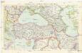
Türkei mit Syrien, Irak und Iran
1 : 3000000 Bospor (Turecko : průliv) Kartogr. Anstalt Freytag-Berndt und Artaria
Russisch-türkischer Kriegsschauplatz, 1877
1 : 3700000 Balkánský poloostrov Petermann, A. Justus Perthes
Russisch-türkischer Kriegsschauplatz, 1877
1 : 3700000 Petermann, August Perthes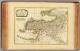
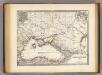
Turquie d'Asie.
1 : 7100000 Bonne, Rigobert, 1727-1794