Maps of Africa

Afrika
Atlas der Pflanzengeographie über alle Theile der Erde Rudolphi, Ludwig Verlag der Nicolaischen Buchhandlung
[Kaart], uit: Karte von Afrika / entworfen von F. Handtke ; bearbeitet und ergänzt im kartographischen Institut der Verlagshandlung
1 : 14500000 titelvariant: General-Karte von Afrika; Annotatie: Omslagtitel: General-Karte von Afrika; Annotatie geografische gegevens: Schaalstokken; Inzetkrt.: Das Deutsche Reich. - 1.14.500.000; Das mittlere Ost-Afrika. - 1.6.000.000. - Zum Vergleich: [Kgr. Sachsen] (elfde schaal); I. Lüderitz-Land (der südliche Theil von Deutsch-Südwestafrika, II. Das Kamerun-Gebiet, III. Togo-Gebiet und Sklavenküste (alle 1:3.000.000). - [Zum Vergleich:] Das Königr. Sachsen (zelfde schaal) Verlag von Carl Flemming, Glogau. Kartographisches Institut Glogau : Carl Flemming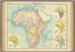
Africa - political.
1 : 23000000 John Bartholomew and Son
Africa
Afrika Hase, Johann Matthias Hauer, Daniel Adam impensis Homannianorum Heredum
Africa
Afrika Hase, Johann Matthias impensis Homannianorum Heredum
Africa
1 : 18500000 entw. und gezeichnet von C. F. Weiland Weimar : Verlag des Geograph. Instituts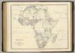
Africa.
1 : 19008000 Johnston, Alexander Keith, 1804-1871
Afrika
Adolf Stieler's Handatlas über alle Theile der Erde und über das Weltgebäude Stieler, Adolf Justus Perthes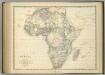
Africa.
1 : 19008000 Johnston, Alexander Keith
Africa.
1 : 50000000 Seaman, James V.
Africae noviss. cateres tabula
1 : 22200000 auct. J. Bormeester [Amsterdam] : [s.n.]
[Neuer Atlas der ganzen Erde nach den neuesten Bestimmungen ... : IV.] Afrika
Entworfen und gezeichnet von Dr. F.W. Streit H. Leutemann sc. Leipzig : J.C. Hinrichs'sche Buchhandlung
Composite: Africa.
1 : 8300000 Robert Laurie & James Whittle
L'Afrique en 1840.
1 : 40000000 Houze, Antoine Philippe
[Historisch-geographischer Atlas zu den allgemeinen Geschichtswerken von C. v. Rotteck, Pölitz u. Becker] : Afrika Uebersichtsblatt für die Geschichte und die geographischen Entdeckungen
von Julius Loewenberg Lithographie von B. Herder in Freiburg im Breisgau [Freiburg im Breisgau] : [Herder]
Africa
1 : 31000000 Afrika
Map of Africa
1 : 7000000 Tanner, Henry S.
Afrika.
1 : 23500000 Stein, Christ. Gottfr. Dan.
Africa.
1 : 25000000 Society for the Diffusion of Useful Knowledge (Great Britain)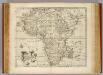
Africa.
1 : 26000000 Bowen, Emanuel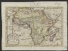
Afrika, volgens de nieuwste waarnemingen
1 : 74000000 Te Amsterdam : by Arend Fokke, Simz.
Afrika
1 : 55500000 Afrika Merklas, Václav
Stanford's library map of Africa / [Edward Stanford]
1 : 5977382 Annotatie: Oorspr. kaart op 4 bl; Oorspr. uitg.: London : Stanford, 1866; De kaart geeft de Britse heerschappij weer tijdens het hoogtepunt van de kolonisatie na de Eerste Wereldoorlog; Annotatie geografische gegevens: Schaalstokken op kaart: Eng: & Ital: Geo: miles; English stat: miles; French kilometres; French leagues; Portuguese leagues; Spanish miles, Turkish berri Edward Stanford 1827-1904 London : Stanford's Geographical Establishment
Africa
1 : 18050000 Afrika Weiland, Karl Ferdinand Verlag des Geograph. Instituts
Africa
1 : 18000000 Afrika Weiland, Karl Ferdinand Mädel Geographisches Institut
CHARTE von AFRICA
1 : 30000000 Afrika
Charte von Africa
1 : 30000000 Afrika
Carte Generale de l'Afrique.
1 : 7000000 Vivien de St Martin, L.
Totius Africae accuratissima tabula [...]
1 : 20000000 denuo correcte revisa, multis locis aucta, in partes tam maiores quam minores divisa per F. de Witt Amstel. [Amsterdam] : ex officina Cóvens et Mortier


