Maps of Carpathian Mountains

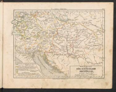
Politische Übersicht von Süd-Deutschland und Oesterreich
E. von Sydow's Schul-Atlas in sechs und dreissig Karten Sydow, Emil von bei Justus Perthes
Österreichisch-ungarische Monarchie
1 : 1900000 Rakousko-Uhersko Handtke, Friedrich Carl Flemming
Karte der OEsterreichischen Monarchie
1 : 3080000 Rakousko-Uhersko Fried, Franz Biller, Dominik Artaria
Karte der OEsterreichischen Monarchie
1 : 3080000 Evropa jihovýchodní Fried, Franz Biller, Dominik Artaria
Karte der OEsterreichischen Monarchie
1 : 3080000 Evropa jihovýchodní Fried, Franz Biller, Dominik Artaria
Karte der OEsterreichischen Monarchie
1 : 3080000 Evropa jihovýchodní Fried, Franz Biller, Dominik Artaria
Avstria
1 : 2850000 Evropa střední v c. k. nakladě škol'nych knižok
Cesarstwo Austryackie
1 : 2740000 Evropa střední w nakładie ksiąg szkolnych
Versuch einer Sprachenkarte der Österreichischen Monarchie
1 : 3000000 von J.V. Haeufler Pest : Emich
Mocnářství rakousko - uherské
Finanz-und Handels-Karte des Oesterreichischen und das zollvereinten Fürstenthums Liechtenstein
Lichtenštejnsko Gábriely, Johann Doležal, Anton K. k. Direction der administrativen Statistik im K. k. Handels-Ministerium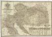
Neueste General- Post- und Strassen Karte der OEsterreichischen Monarchie
1 : 1500000 Evropa jihovýchodní Traux, Maximilian de Fried, Franz Artaria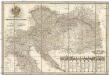
Neueste General- Post- und Strassen Karte der OEsterreichischen Monarchie
1 : 1500000 Evropa jihovýchodní Traux, Maximilian de Fried, Franz Artaria & Compag.ie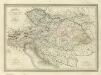
Composite: Carte Generale l'Empire d'Autriche.
1 : 2700000 Vivien de St Martin, L.
Karte der Österreichischen Monarchie
1 : 3500000 Evropa jihovýchodní Biller, Dominic Florian Mollo
Oesterreich
Österreich-Ungarn Skizzenbuch
L'impero d'Austria
1 : 2850000 Evropa střední presso d'i. r. direzione per la vendita dei libri scolastici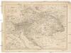
Císarství [sic] rakouské
1 : 2850000 Evropa střední z c. k. školního kněhoskladu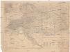
Der Österreichische Kaiser-Staat
1 : 1863880 Evropa jihovýchodní Handtke, Friedrich Adler, C. C. Flemming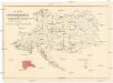
Karte der Thonwaaren-Industrie des Oesterreichischen Monarchie
Rakousko (1804-1867) K. k. Direction der administrativen Statistik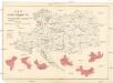
Karte der Glaswaaren-Industrie der Oesterreichische Monarchie
Rakousko (1804-1867) K. k. Direction der administrativen Statistik
Tabula Russiae / ex mandato Foedor Borissowits delineata, Magno studio plurimis in locis aucta, edit
1 : 7900000 1 Karte : Kupferdruck ; 41 x 52 cm Visscher, Claes Jansz. [Nicolas Visscher]
Novissima Russiæ tabula / authore Isaaco Massa
1 : 840000 1 Karte : Kupferdruck ; 46 x 54 cm Massa, Isaac Abrahamsz Apud Janssonio-Waesbergios et Mosem Pitt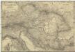
Oestreichs Laender unter den Roemern
1 : 2000000 Evropa jihovýchodní Renner, Emanuel von David, Johann J. G. Heubner
Oestreichs Laender unter den Roemern
1 : 2000000 Evropa jihovýchodní Renner, Emanuel von David, Johann J.G. Heubner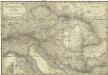
Oestreichs Laender unter den Roemern
1 : 2000000 Evropa jihovýchodní Renner, Emanuel von David, Johann J. G. Heubner
Versuch einer Sprachenkarte der Österreichischen Monarchie
Rakousko (1804-1867) Haeufler, J. V. Riegel, Christoph Gustav Emich
Az Austriai birodalom
1 : 3080000 Rakousko (1804-1867) Karacs, Ferentz Lassú István
Karte der Oesterreichischen Monarchie

Das Kaiserthum Oesterreich
1 : 2800000 Rakousko (1804-1867) im k.k. Schulbücher-Verlage
Das Kaiserthum Oesterreich
1 : 2800000 Rakousko (1804-1867) im k.k. Schulbücher-Verlage