Maps of Polynesia

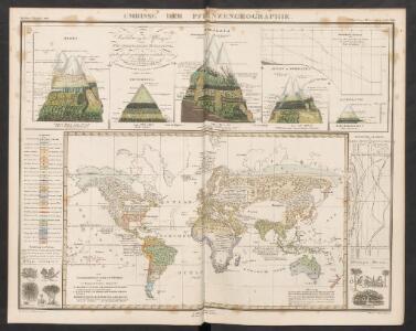
Umrisse der Pflanzengeographie
Zweiter Band, enthaltend in vier Abtheilungen die Vertheilung der Organismen: 5. Pflanzen-Geographie, 6. Thier-Geographie, 7. Anthropographie, 8. Ethnographie Humboldt, Alexander von Verlag von Justus Perthes
The "time and tide" map of the Atlantic charter / [cartography] London Geographical Institute
1 : 450000 Annotatie: Bevat de 8 punten van het Atlantisch charter The London Geographical Institute, London London : Philip & Son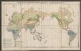
Vertheilung der wichtigsten physiologischen Pflanzengruppen in den Vegetationsgebieten der Erde
1 : 85000000 Engler, Adolf Wagner & Debes
[Survey of the Geographical distribution and cultivation of the most important Plants which are used as food for man]
The physical atlas Johnston, Alexander Keith William Blackwood & Sons
[Geographische Verbreitung der Menschen-Rassen]
Zweiter Band, enthaltend in vier Abtheilungen die Vertheilung der Organismen: 5. Pflanzen-Geographie, 6. Thier-Geographie, 7. Anthropographie, 8. Ethnographie Humboldt, Alexander von Verlag von Justus Perthes
Verbreitung der Vögel I.
Atlas der Tierverbreitung Marshall, William Justus Perthes
World - bathy-orographical.
1 : 83000000 John Bartholomew and Son
Verbreitung der Vögel II.
Atlas der Tierverbreitung Marshall, William Justus Perthes
[Verbreitungsbezirke der wichtigsten Kulturgewächse]
Zweiter Band, enthaltend in vier Abtheilungen die Vertheilung der Organismen: 5. Pflanzen-Geographie, 6. Thier-Geographie, 7. Anthropographie, 8. Ethnographie Humboldt, Alexander von Verlag von Justus Perthes
Facsimile: Langsdorff's Map of the World.
1 : 92000000 Von Langsdorff, G.H.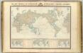
Navigation, les oceans.
1 : 67000000 Garnier, F. A., 1803-1863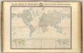
Thermometrie.
1 : 70000000 Garnier, F. A., 1803-1863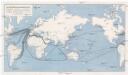
Die Weltmeere als Kriegsschauplatz
1 : 75000000 země světa Volk und Reich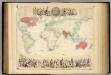
British Empire Throughout the World Exhibited In One View.
1 : 30000000 Fullarton, A. & Co.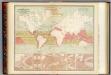
Currents of air.
1 : 70000000 Johnston, Alexander Keith, 1804-1871
Seven Puzzle Maps of the World.
Logerot
Vertheilung der Nagethiere und Wiederkauer.
1 : 130000000 Berghaus, Heinrich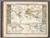
Verbreitungsbezirke Der Wichtigsten Kulturgewachse.
1 : 130000000 Berghaus, Heinrich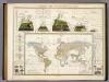
Umrisse Der Pflanzengeographie.
1 : 130000000 Berghaus, Heinrich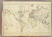
(World map)
1 : 75000000 Bowen, Frances
Planisphère illustré présentant la description géographique des parties connues de la terre : indiquant l'époque des grandes découvertes et le nom des navigateurs, les colonies des diverses nations ainsi que le parcours des bateaux à vapeur, l'époque des départs, la durée du trajet &c. / dressé par Vuillemin ; gravé par Langevin
1 : 34000000 Annotatie: Met diverse kostuumfiguren, overzicht van de hoogste bergen en overzicht van de langste rivieren Vuillemin, A.; Langevin, ... Paris : Fatout
[Terra]
země světa
Linien gleicher Deklination (Isogonen)
Atlas des Erdmagnetismus Neumayer, Georg Justus Perthes
Planiglob in Mercators Projection
země světa Berra, Marco bei Marco Berra
Windkarte der Erde
Erster Band, enthaltend in vier Abtheilungen die Erscheinungen der anorganischen Natur: 1. Meteorologie und Klimatographie. 2. Hydrologie und Hydrographie. 3. Geologie. 4. Tellurischer Magnetismus Humboldt, Alexander von Verlag von Justus Perthes
Geographische Verbreitung der Menschen-Rassen.
1 : 140000000 Berghaus, Heinrich
Mercator's Chart.
1 : 91000000 Lucas, Fielding Jr.
Übersicht der Erde
Atlas der Geologie Zittel, K.v. ; Berghaus, Hermann Justus Perthes
DIE ERDE in Zwey Halbkugeln der östlichen und westlichen
země světa