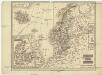
Maps of Scandinavia

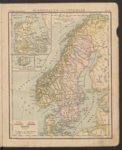
Skandinavien und Dänemark
Volksschul-Atlas über alle Teile der Erde Lange, Henry Druck und Verlag von Georg Westermann
Missions catholiques des pays scandinaves
1 : 2200000 [Lyon : Oeuvre de la propagation de la foi]
Nordeuropa 1922
Nordeuropa Kunz, Andreas ; Treiling, Thomas
The countries of northern Europe
Schweden und Norwegen
1 : 11400000 Dánsko
Spesielle kart 129-3: Oversigtskart over fà ̧rste ordens trianguleringen og præcisionsnivellementet
1 : 2800000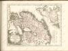

Sweden, Denmark, Norway (outline)
1 : 8500000 Patteson, Edward
Sweden, Denmark, Norway.
1 : 8500000 Patteson, Edward
Spesielle kart 77: Bathymetrical and hypsometrical map of Norway
1 : 2400000 Kristiania Lithografiske Aktiebolag
Statistikk 42: Døgnets normaltemperatur i Skandinavia, april måned
1 : 4000000
[Scandinavien und Dänemark]
[Allgemeiner Atlas über alle Theile der Erde in 29 Blättern] Ziegler, Jakob Melchior Top. Anstalt v. J. Wurster u. Comp.
Nordeuropa 1937
Nordeuropa Kunz, Andreas ; Treiling, Thomas
Nordeuropa 1814
Nordeuropa Kunz, Andreas ; Treiling, Thomas
Nordeuropa 1905
Nordeuropa Kunz, Andreas ; Röss, Wolf ; Johnen, Bettina ; Moeschl, Joachim Robert
Nordeuropa 1914
Nordeuropa Kunz, Andreas ; Röss, Wolf ; Johnen, Bettina ; Moeschl, Joachim Robert
Nordeuropa 1865
Nordeuropa Kunz, Andreas ; Röss, Wolf ; Johnen, Bettina ; Moeschl, Joachim Robert
Nordeuropa 1809
Nordeuropa Kunz, Andreas ; Treiling, Thomas
Nordeuropa 1815
Nordeuropa Kunz, Andreas ; Treiling, Thomas
Nordeuropa 1871
Nordeuropa Kunz, Andreas ; Röss, Wolf ; Johnen, Bettina ; Moeschl, Joachim Robert
Nordeuropa 1949
Nordeuropa Kunz, Andreas ; Treiling, Thomas
Statistikk 42: Døgnets normaltemperatur i Skandinavia, januar måned
1 : 4000000
Nordeuropa 1820
Nordeuropa Kunz, Andreas ; Röss, Wolf ; Johnen, Bettina ; Moeschl, Joachim Robert
Karte der beiden Königreiche Schweden u. Norwegen
Neuester Schul-Atlas Walch, Johann im Verlag bei Joh. Walch
Nordeuropa 1789
Nordeuropa Kunz, Andreas ; Treiling, Thomas
Skandinavien oder Schweden und Norwegen
Schul-Atlas in 36 Karten Völter, Daniel Verlag der J.M. Dannheimer'schen Buchhandlung

Spesielle kart 130-2: Oversigt over tætbebyggelse, stà ̧rre industrielle bedrifter og vigtige gruber ...
1 : 2800000
[Schweden und Norwegen oder Scandinavische Halbinsel Königreich Daenemark]
Geographischer Atlas über alle Theile der Erde Ziegler, Jakob Melchior Verlag von Dietrich Reimer