Maps of South America

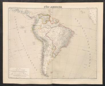
Süd-America
Neuer Handatlas über alle Theile der Erde Kiepert, Heinrich Verlag von Dietrich Reimer
Süd-America
Handatlas über alle Theile der Erde und über das Weltgebäude Stieler, Adolf Justus Perthes
Süd-America
Hand-Atlas über alle Theile der Erde und über das Weltgebäude Stieler, Adolf Justus Perthes
Sud-America.
1 : 27750000 Stulpnagel, F.v.
[Süd-Amerika]
Hypsometrischer Atlas Ziegler, Jakob Melchior Topogr. Anstalt v. J. Wurster u. Comp.
Süd-America
Hand-Atlas über alle Theile der Erde nach dem neuesten Zustande und über das Weltgebäude Stieler, Adolf bei Justus Perthes
Süd Amerika
Geographischer Atlas über alle Theile der Erde Ziegler, Jakob Melchior Verlag von Dietrich Reimer
Süd-Amerika
[Allgemeiner Atlas über alle Theile der Erde in 29 Blättern] Ziegler, Jakob Melchior Top. Anstalt v. J. Wurster u. Comp.
Süd-America
Schul-Atlas über alle Theile der Erde nach dem neuesten Zustande, und über das Weltgebäude Stieler, Adolf bei Justus Perthes
Süd-Amerika
Adolf Stieler's Handatlas über alle Theile der Erde und über das Weltgebäude Stieler, Adolf Justus Perthes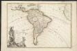
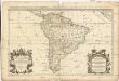
L'Amerique meridionale divisée en ses principaux etats
1 : 1
Süd-America
Hand-Atlas über alle Theile der Erde nach dem neuesten Zustande und über das Weltgebäude Stieler, Adolf bei Justus Perthes
Jižní Amerika
Jižní Amerika
Ethnographische Karte von Süd-Amerika
Zweiter Band, enthaltend in vier Abtheilungen die Vertheilung der Organismen: 5. Pflanzen-Geographie, 6. Thier-Geographie, 7. Anthropographie, 8. Ethnographie Humboldt, Alexander von Verlag von Justus Perthes
Amerique du Sud.
1 : 16800000 Andriveau-Goujon, J.
Süd-America
Schul-Atlas über alle Theile der Erde nach dem neuesten Zustande, und über das Weltgebäude Stieler, Adolf Justus Perthes
L'Amerique Meridionale divisée en ses principales parties
1 : 16000000
Süd-Amerika
Plastischer Schul-Atlas über alle Theile der Erde : in 24 Karten Woldermann, G Verlag von P. Eckerlein
Süd-America
1 : 28500000 entw. u. gez. v. Pr. Lt. v. Stülpnagel gestochen v. L. Thiel Gotha : Perthes
149-50. America Meridionale fisica.
1 : 20000000 Touring club italiano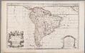
South America, divided into its principall parts viz. the Firm-Land, Peru, Chili, Brasil, Paraguay the Magellanick Land and Islands, in which are distinguished the severall countries as they are at present possessed by the Spanish, English, Portugals, French, and Dutch, etc. / described by Sanson ; corr. and amended by William Berry
1 : 16000000 titelvariant: South America, divided into its principall parts, where are distinguished the severall states which belong to the Spanish, English, Portugals, and French; Annotatie: Titel in cartouche linksonder: South America, divided into its principall parts, where are distinguished the severall states which belong to the Spanish, English, Portugals, and French; Met opdracht aan Charles II Sanson, Nicolas; Berry, William London : William Berry
Map of South America.
1 : 15400000 Finley, Anthony
Jižní Amerika
1 : 46500000 Jižní Amerika Merklas, Václav
[Süd-Amerika]
Atlas der Geologie Zittel, K.v. ; Berghaus, Hermann Justus Perthes

Jižní Amerika
1 : 28000000 Jižní Amerika Merklas, Václav W. Merklas
Jižní Amerika
1 : 28000000 Jižní Amerika Merklas, Václav W. Merklas
A map of South America containing Tierra-Firma, Guayana, New Granada, Amazonia, Brasil, Peru, Paraguay, Chaco, Tucuman, Chili and Patagonia / from Mr. D'Anville with several improvements and additions and the newest discoveries
1 Mapa, col. Anville, J.B. d' ; Laurie & Whittle published by Laurie & Whittle as the Act directs
Jižní Amerika.