Maps of South America

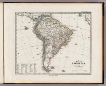
Sud-America.
1 : 27750000 Stulpnagel, F.v.
Süd-America
Hand-Atlas über alle Theile der Erde und über das Weltgebäude Stieler, Adolf Justus Perthes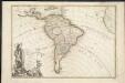
L'Amerique meridionale divisée en ses principaux etats
1 : 1
Süd-America
Handatlas über alle Theile der Erde und über das Weltgebäude Stieler, Adolf Justus Perthes
Süd-Amerika
[Allgemeiner Atlas über alle Theile der Erde in 29 Blättern] Ziegler, Jakob Melchior Top. Anstalt v. J. Wurster u. Comp.
[Süd-Amerika]
Hypsometrischer Atlas Ziegler, Jakob Melchior Topogr. Anstalt v. J. Wurster u. Comp.
149-50. America Meridionale fisica.
1 : 20000000 Touring club italiano
Süd-America
Neuer Handatlas über alle Theile der Erde Kiepert, Heinrich Verlag von Dietrich Reimer
Ethnographische Karte von Süd-Amerika
Zweiter Band, enthaltend in vier Abtheilungen die Vertheilung der Organismen: 5. Pflanzen-Geographie, 6. Thier-Geographie, 7. Anthropographie, 8. Ethnographie Humboldt, Alexander von Verlag von Justus Perthes
[Süd-Amerika]
Atlas der Geologie Zittel, K.v. ; Berghaus, Hermann Justus Perthes
Süd Amerika
Geographischer Atlas über alle Theile der Erde Ziegler, Jakob Melchior Verlag von Dietrich Reimer
Jižní Amerika
1 : 46500000 Jižní Amerika Merklas, Václav
L'Amerique Meridionale divisée en ses principales parties
1 : 16000000
Amerique du Sud.
1 : 16800000 Andriveau-Goujon, J.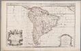
South America, divided into its principall parts viz. the Firm-Land, Peru, Chili, Brasil, Paraguay the Magellanick Land and Islands, in which are distinguished the severall countries as they are at present possessed by the Spanish, English, Portugals, French, and Dutch, etc. / described by Sanson ; corr. and amended by William Berry
1 : 16000000 titelvariant: South America, divided into its principall parts, where are distinguished the severall states which belong to the Spanish, English, Portugals, and French; Annotatie: Titel in cartouche linksonder: South America, divided into its principall parts, where are distinguished the severall states which belong to the Spanish, English, Portugals, and French; Met opdracht aan Charles II Sanson, Nicolas; Berry, William London : William Berry
Jižní Amerika
Jižní Amerika
Süd-America
Hand-Atlas über alle Theile der Erde nach dem neuesten Zustande und über das Weltgebäude Stieler, Adolf bei Justus Perthes
South America.
1 : 25344000 Carey, Mathew
Map Of South America.
1 : 25344000 Carey, Mathew
South America.
1 : 26000000 Carey, Mathew
Map Of South America.
1 : 25344000 Carey, Mathew
South America
Este mapa, sin fecha y sin autor conocido, probablemente sea de mediados del siglo XVIII. La representación de Islas Malvinas a partir del Estrecho de Falkland, como era común en la primera mitad del siglo XVIII, es un indicio en ese sentido. En enero de 1690 el inglés John Strong navegó entre las dos islas principales y llamó al paso "Falkland Channel" en honor a su mecenas el Vizconde de Falkland que como había financiado la expedición. La cartografía británica adoptaría en el siglo XVIII el nombre del canal, para designar a todo el grupo de islas, que reclamaría para Inglaterra, en contra de España. En 1740 hubo un enfrentamiento naval entre las fuerzas británicas y españolas por las islas, sin un claro vencedor. Las tensiones entre los dos imperios continuaría a lo largo del siglo XVIII.
Map of South America.
1 : 15400000 Finley, Anthony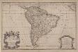
South America divided into its principall parts where are distinguished the severall states which belong to the Spanish, English, Portugals, and French
1 : 16000000 Berry, William, fl. 1669-1708 Sold by William Berry at the sign of the Globe between Charing-Cross and White-Hall
Süd-America
Schul-Atlas über alle Theile der Erde nach dem neuesten Zustande, und über das Weltgebäude Stieler, Adolf bei Justus Perthes
Süd-America
Hand-Atlas über alle Theile der Erde nach dem neuesten Zustande und über das Weltgebäude Stieler, Adolf bei Justus Perthes
South America.
1 : 32000000 Smiley, Thomas T.
Süd-Amerika
Adolf Stieler's Handatlas über alle Theile der Erde und über das Weltgebäude Stieler, Adolf Justus Perthes

Jižní Amerika
1 : 28000000 Jižní Amerika Merklas, Václav W. Merklas