Maps of United States

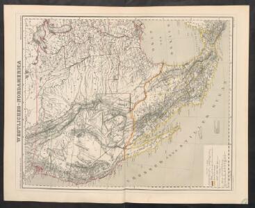
Westliches-Nordamerica
Neuer Handatlas über alle Theile der Erde Kiepert, Heinrich Verlag von Dietrich Reimer
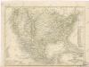
Composite: Map of Louisiana and Mexico.
1 : 4300000 Tardieu, P.F.
Maris Pacifici, America.
Schoner, Johann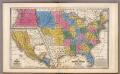
United States ... Texas ... Mexico and Guatimala.
1 : 11404800 Mitchell, Samuel Augustus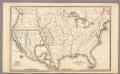
Map of the United States and Texas ... Mexico and Guatimala.
1 : 11404800 Mitchell, Samuel Augustus
Central America and Yucatan (Mexico).
from The cerographic atlas of the United States. By Sidney E. Morse, A.M., and Samuel Breese, A.M.
Vereinigten Staaten von Nordamerika, West-Hälfte
Geographischer Atlas über alle Theile der Erde Ziegler, Jakob Melchior Verlag von Joh. Wurster um Comp.
Map Of The United States.
1 : 13168000 U.S. War Department, Topographical Engineers
Washington Map of the United States.
1 : 13000000 Taintor, S. & Co.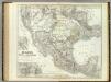
Mexico, Texas, Californien, C. America.
1 : 6000000 Kiepert, Heinrich, 1818-1899
Naval And Military Map Of The United States.
1 : 3300000 Smith, Robert P.
Neueste Karte von Mexico
Grosser Hand-Atlas über alle Theile der Erde in 170 Karten Meyer, J. Verlag des Bibliographischen Instituts
Mexico, Texas und Californien
1 : 6000000 bearb. und gezeichnet von H. Kiepert Situation und Schrift gestochen von K. Mädel ; Terrain von C. Jungmann Weimar : Verlag des Geographischen Institus
Map Atlantic Coast Line.
1 : 12503000 Atlantic Coast Line Railroad Company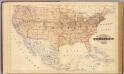
Topographical map of the United States.
1 : 9500000 Andreas, A. T. (Alfred Theodore), 1839-1900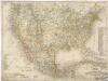
Vereinigte Staaten von Nord America - und Mexico
Vereinigte Staaten von Nord - America und Mexico

North America, 1722.
1 : 25000000 Wells, Edward
Composite: Vereinigte Staaten von NordAmerika, nebst Mexico und Centralamerika.
1 : 7000000 Stein, Christ. Gottfr. Dan.
Washington Map of the United States.
1 : 3000000 Taintor, S. & Co.
Nouvelle Carte du Mexique, Du Texas.
1 : 4800000 Brue, Adrien Hubert, 1786-1832
[Verein-Staaten von Nord-America, Mexico, Yucatan u.A.]
Handatlas über alle Theile der Erde und über das Weltgebäude Stieler, Adolf Justus Perthes
Atlas für Handel und Industrie: Für Kaufleute, Fabrikante u. Gewerbetreibende, Handlungs- u. Gewerbe-Schulen
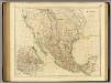
Mexico.
1 : 6650000 Arrowsmith, John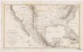
Carte du Mexique : et des pays limitrophes situés au nord et à l'est
1 : 8000000 Poirson, J. B F. Schoell
[Vereinigte Staaten v. Nord-Amerika nebst Mexico und Canada]
[Allgemeiner Atlas über alle Theile der Erde in 29 Blättern] Ziegler, Jakob Melchior Top. Anstalt v. J. Wurster u. Comp.
Reyno de la Nueva Expana a Principios del Siglo XIX.
1 : 7349760 Garcia Cubas, Antonio, 1832-1912
Map of the United States and Mexico: including Oregon, Texas and the Californias.
from Parts s.n.: [New York?],
Composite: (U.S. West) Railroad Map of the United States.
1 : 1140480 Rand McNally and Company