Maps of Switzerland

Die Schweiz auch Fürstenthum Liechtenstein
Schul-Atlas über alle Theile der Erde nach dem neuesten Zustande, und über das Weltgebäude Stieler, Adolf Justus Perthes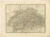

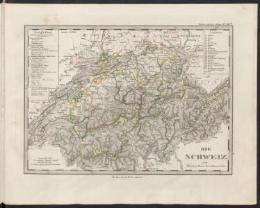
Die Schweiz
Plastischer Schul-Atlas über alle Theile der Erde : in 24 Karten Woldermann, G Verlag von P. Eckerlein
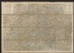
Carte de Suisse
1 Karte dressé sur les memoires de Merveilleux par Guillaume de l'Isle chez l'auteur sur le Quay de l'Horloge, Paris
Switzerland.
1 : 1000000 Colton, G.W.
Novissima et accuratissima Helvetiae, Rhaetiae, Valesiae, et partis Sabaudiae tabula.
Amsterdam : ex officina R. & J. Ottens
Carte pour l'histoire ancienne de l'Helvétie
1 Karte auf 4 Bl. [Charles Guillaume Loys de Bochat] ; [Jean Philippe Loys de Cheseaux] chés Bousquet, Lausanne
Petite carte de la Suisse pour les écoles
1 : 800000 1 Karte gezeichnet und herausgegeben von H. Keller Heinrich Keller, untere Zäune No. 367, Zürich

Helvetia cum finitimis regionibus confoederatis. [Karte], in: Gerardi Mercatoris Atlas, sive, Cosmographicae meditationes de fabrica mundi et fabricati figura, S. 261.
1 Karte aus Atlas Mercator, Gerhard Montanus, Petrus
Die Schweiz
Stieler's Hand-Atlas Stieler, Adolf bei Justus Perthes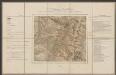
Helvetia cum finitimis regionibus confoederatis. [Karte], in: Gerardi Mercatoris et I. Hondii Newer Atlas, oder, Grosses Weltbuch, Bd. 1, S. 256.
1 Karte aus Atlas Mercator, Gerhard und Hondius, Jodocus Jansson, Jan
Umriss von der Schweiz nach der neuen Eintheilung von 1798
1 Karte : Kupferdruck ; 36 x 48 cm s.n.

Geographisches Verzeichniss der merkwürdigsten Orte in der Schweiz
1 : 700000 1 Karte Hein. Körner delin. ; J. Rodolf Holzhalb sculps. [Verlag nicht ermittelbar], [Zürich?]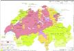
Innerer Aufbau der Schweiz 1648
Schweiz Verwaltungsgliederung Kunz, Andreas ; Moeschl, Joachim Robert
Nova Helvetiae tabula geographica illustrissimis et potentissimis cantonibus et rebuspublicis reformatae religionis Tigurinae, Bernensi, Glaronensi, Basiliensi, Scaphusianae, Abbatis Cellanae
1 : 230000 1 Karte auf 4 Bl. dominis suis clementissimis humillime dicata a Ioh. Iacobo Scheuchzero Tigurino, 1712 ; Ioh. Melch. Füsslin ornamenta pinx. ; Ioh. Henr. Huber et Eman. Schalch sculps. [Hofmeister], [Zürich]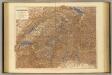
Switzerland.
1 : 506880 Stanford, Edward
Switzerland.
1 : 1457280 Lucas, Fielding Jr.
Carte en relief de la Suisse / par Ed. Beck à Berne = Relief-Karte der Schweiz / von Ed. Beck in Bern
1 : 900000 Annotatie: Beschreven in: Das Landschaftsrelief : Symbiose von Wissenschaft und Kunsthandwerk / Toni Mair, Susanne Grieder. - Baden : Hier + Jetzt ; [etc.], 2006. - P. 154 Eduard Beck 1820-1900 Bern : Verlag v. Ed. Beck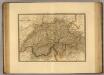
Suisse.
1 : 745000 Picquet, C.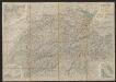
Roadmap of Switzerland
1 : 355000 Müllhaupt, Hans Heinrich ; Bressanini, Rinaldo ; Leuthold, Hans Felix Leuthold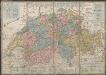
Petite carte de la Suisse pour les écoles
1 : 800000 Keller, Heinrich [H. Keller'sgeogr. Verlag]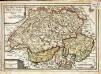
Les XIII. cantons des Suisses leurs alliez et leurs sujets
1 Karte : Kupferdruck ; 22 x 32 cm Fer; Inselin chez l'auteur dans l'isle du Palais a la sphere royale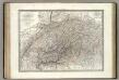
La Suisse.
1 : 700000 Lapie, M. (Pierre), 1779-1850
Geologische Karte der Schweiz
1 : 500000 Švýcarsko Leuzinger, Rudolf Kommisionverlag von A. Francke
Nova Helvetiae, foederatarumque cum ea, nec non subditarum regionum tabula, ad usum serenissimi Burgundiae ducis, secundum commentarios domini Merveilleux
1 Karte composita per Guilielmum de l'Isle apud Joh. Covens & Corn. Mortier, Amstelodami
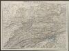
Helvetiae, Rhaetiae et Valesiae caeterorumque confoederatorum ut & finitimorum populorum tabula geographica et hydrographica nova & exacta
1 : 500000 1 Karte operâ & studio Ioh. Conradi Gygeri delineata & à Conrado Meyero in aes incisa, anno Christi 1657 [Verlag nicht ermittelbar], [Zürich]