Maps of Switzerland

Geologische Karte der Schweiz
1 : 500000 Švýcarsko Leuzinger, Rudolf Kommisionverlag von A. Francke
Les XIII. cantons des Suisses leurs alliez et leurs sujets
1 Karte : Kupferdruck ; 22 x 32 cm Fer; Inselin chez l'auteur dans l'isle du Palais a la sphere royale
Umriss von der Schweiz nach der neuen Eintheilung von 1798
1 Karte : Kupferdruck ; 36 x 48 cm s.n.
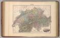
Die Schweiz auch Fürstenthum Liechtenstein
Schul-Atlas über alle Theile der Erde nach dem neuesten Zustande, und über das Weltgebäude Stieler, Adolf Justus Perthes

Carte de Suisse
1 Karte dressé sur les memoires de Merveilleux par Guillaume de l'Isle chez l'auteur sur le Quay de l'Horloge, Paris
Die Schweiz
Plastischer Schul-Atlas über alle Theile der Erde : in 24 Karten Woldermann, G Verlag von P. Eckerlein
Die Schweiz

Petite carte de la Suisse pour les écoles
1 : 800000 1 Karte gezeichnet und herausgegeben von H. Keller Heinrich Keller, untere Zäune No. 367, Zürich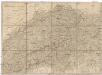
Helvetien und Wallis
Švýcarsko Mechel, Christian von Weiss, Johann Heinrich im Verlage des Kunst u. Industrie Comptoirs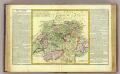
La Suisse.
1 : 980000 Clouet, J. B. L. (Jean-Baptiste Louis), b. 1730
Switzerland.
1 : 950000 Hughes, William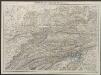
Helvetia cum finitimis regionibus confoederatis. [Karte], in: Gerardi Mercatoris Atlas, sive, Cosmographicae meditationes de fabrica mundi et fabricati figura, S. 261.
1 Karte aus Atlas Mercator, Gerhard Montanus, Petrus
Carte générale de la Suisse suivant les nouvelles divisions, qui comprennent les ci-devant XIII cantons, leurs alliés et sujets, et forment actuellement la république helvétique une et invisible
1 : 525000 Mechel, Christian von Chrétien de Mechel

Die Helvetische Republik in Cantone und Districte eingetheilt
1 Karte : Typometrie ; 36 x 49 cm Haas gedruckt bey Wilhelm Haas dem Sohne
Carte pour l'histoire ancienne de l'Helvétie
1 Karte auf 4 Bl. [Charles Guillaume Loys de Bochat] ; [Jean Philippe Loys de Cheseaux] chés Bousquet, Lausanne
[Karte der Schweiz]
1 Karte : Kupferdruck ; 16 x 20 cm Heidegger; Halder s.n.
Switzerland.
1 : 1000000 Colton, G.W.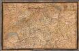
Carte en relief de la Suisse / par Ed. Beck à Berne = Relief-Karte der Schweiz / von Ed. Beck in Bern
1 : 900000 Annotatie: Beschreven in: Das Landschaftsrelief : Symbiose von Wissenschaft und Kunsthandwerk / Toni Mair, Susanne Grieder. - Baden : Hier + Jetzt ; [etc.], 2006. - P. 154 Eduard Beck 1820-1900 Bern : Verlag v. Ed. Beck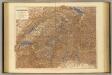
Switzerland.
1 : 506880 Stanford, Edward
Switzerland.
1 : 1300000 Finley, Anthony
Novissima et accuratissima Helvetiae, Rhaetiae, Valesiae, et partis Sabaudiae tabula.
Amsterdam : ex officina R. & J. Ottens
Suisse.
1 : 795000 Migeon, J.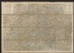
Karte der Schweiz
1 : 400000 Leuzinger, Rudolf J. Dalp (C. Schmid)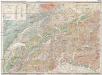
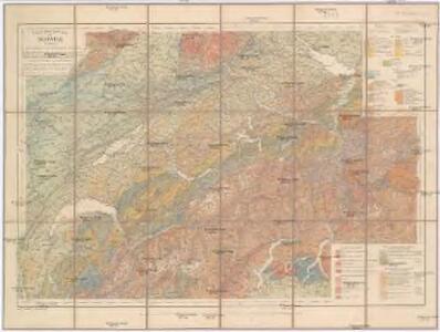
Carte geologique de la Suisse
1 : 380000 Švýcarsko Studer, B. Escher, A. J. Wurster & Comp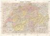
Suisse - Schweiz
1 : 300000 Švýcarsko Kümmerly & Frey
La Suisse
1 Karte : Kupferdruck ; 46 x 63 cm Bonne; Lattré chés Lattré grav.r ord. de Mons.gr le Dauphin ruë S. Jacques à la ville de Bordeaux