Maps of Třemešná

Alt Reigelsdorf - m2634-1-001 - Kaiserpflichtexemplar der Landkarten des stabilen Katasters
1 : 2880
Alt Reigelsdorf - m2634-1-002 - Kaiserpflichtexemplar der Landkarten des stabilen Katasters
1 : 2880
Olbersdorf - m1770-1-005 - Kaiserpflichtexemplar der Landkarten des stabilen Katasters
1 : 2880
Olbersdorf - m1770-1-001 - Kaiserpflichtexemplar der Landkarten des stabilen Katasters
1 : 2880
Olbersdorf - m1770-1-002 - Kaiserpflichtexemplar der Landkarten des stabilen Katasters
1 : 2880
Olbersdorf - m1770-1-004 - Kaiserpflichtexemplar der Landkarten des stabilen Katasters
1 : 2880
Olbersdorf - m1770-1-003 - Kaiserpflichtexemplar der Landkarten des stabilen Katasters
1 : 2880
Olbersdorf - m1770-1-007 - Kaiserpflichtexemplar der Landkarten des stabilen Katasters
1 : 2880
Olbersdorf - m1770-1-008 - Kaiserpflichtexemplar der Landkarten des stabilen Katasters
1 : 2880
Olbersdorf - m1770-1-006 - Kaiserpflichtexemplar der Landkarten des stabilen Katasters
1 : 2880
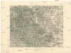
Meßtischblatt 5871 : Troplowitz, 1936
1 : 250000 Troplowitz. - Hrsg. 1883, bericht. 1902, einz. Nachtr. 1930, gedr. [19]36. - 1:25000. - [Berlin]: Reichsamt für Landesaufnahme, 1936. - 1 Kt.
Krnov
1 : 75000 Krnov (Česko : oblast) Vojenský zeměpisný ústav
Krnov
1 : 75000 Krnov-oblast (Česko) Vojenský zeměpisný ústav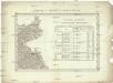
Umgebungen von Jägerndorf
Krnov-oblast (Česko) Enthoffer, J.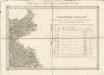
II. vojenské mapování 2
1 : 144000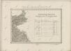
II. vojenské mapování 2
1 : 144000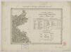
II. vojenské mapování 2
1 : 144000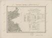
II. vojenské mapování 2
1 : 144000
III. vojenské mapování 3959
1 : 75000
Jägerndorf
1 : 75000 Krnov (Česko : oblast) Schuberth K. u. k. Militärgeographisches Institut
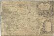
Karte des politischen Bezirkes Jägendorf

Krnovsko a Osoblažsko

Podrobná mapa Markrabství moravského a Vévodství slezkého
1 : 100000 Bruntál (Česko : oblast) Srp, Jan Jos. R. Vilímek
Karte des politischen Bezirkes Freudenthal

Hotzenplotz und Zuckmantel.
from Spezialkarte der osterreichisch-ungarischen Monarchie.
Jacerndorf.
from Spezialkarte der osterreichisch-ungarischen Monarchie.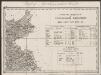
Umgebungen von Jägerndorf und die statistische Uebersicht
1 : 144000 K.K. Militärisches Geographisches Institut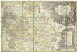
Principatvs Silesiae Karnoviensis nova et exactissima tabula geographica commonstrans insimul districtus ac statvs minores Frevdenthal, Olbersdorf et Stevberndorf
1 : 100000 Bruntál-oblast (Česko) Wieland, Johann Wolfgang Schubarth, Matthäus Homannianos Heredes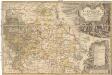
Principatvs Silesiae Karnoviensis nova et exactissima tabula geographica commonstrans insimul districtus ac statvs minores Frevdenthal Olbersdorf et Stevberndorf
1 : 100000 Bruntál-oblast (Česko) Wieland, Johann Wolfgang Schubarth, Matthäus ab Haeredibus Homannianis