Maps of powiat prudnicki

Hotzenplotz und Zuckmantel.
from Spezialkarte der osterreichisch-ungarischen Monarchie.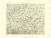
III. vojenské mapování 3859
1 : 75000
III. vojenské mapování 3859
1 : 75000
Hotzenplotz und Zuckmantel
1 : 75000 Morava (Česko) Radler K. u. k. Militärgeographisches Institut
Podrobná mapa Markrabství moravského a Vévodství slezkého
1 : 100000 Moravské markrabství Srp, Jan Jos. R. Vilímek
[Kartenblatt]
1 : 25000 Morava (Česko) Reichsamt für Landesaufnahme
[Kartenblatt]
1 : 25000 Morava (Česko) Reichsamt für Landesaufnahme

III. vojenské mapování 3859/3
1 : 25000
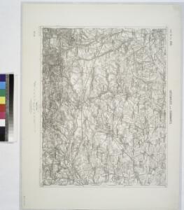
Meßtischblatt 5771 : Kunzendorf, 1936
1 : 250000 Kunzendorf. - Hrsg. 1884, einz. Nachtr. 1912. - 1:25000. - [Berlin]: Reichsamt für Landesaufnahme, [19]36. - 1 Kt.
Meßtischblatt 3344 : Arnoldsdorf, 1884
1 : 250000 Arnoldsdorf. - Aufn. 1883. - 1:25000. - [Berlin]: Kgl. Preuss. Landesaufnahme, 1884. - 1 Kt.
Meßtischblatt 5772 : Leobschütz, 1930
1 : 250000 Leobschütz. - Hrsg. 1883, bericht. 1902, einz. Nachtr. 1930. - 1:25000. - [Berlin]: Reichsamt für Landesaufnahme, 1930. - 1 Kt.
Meßtischblatt 5671 : Neustadt O.S., 1935
1 : 250000 Neustadt O.S. - Hrsg. 1884, einz. Nachtr. 1930. - 1:25000. - [Berlin]: Reichsamt für Landesaufnahme, [19]35. - 1 Kt.
Meßtischblatt 5670 : Ziegenhals, 1936
1 : 250000 Ziegenhals. - Hrsg. 1885, einz. Nachtr. 1930, gedr. [19]36. - 1:25000. - [Berlin]: Reichsamt für Landesaufnahme, 1936. - 1 Kt.
Meßtischblatt 3300 : Ziegenhals, 1912
1 : 250000 Ziegenhals. - Aufn. 1883, hrsg. 1885, Nachtr. [19]12. - 1:25000. - [Berlin]: Kgl. Preuss. Landesaufnahme, 1912. - 1 Kt.
Meßtischblatt 3302 : Deutsch Rasselwitz, 1936
1 : 250000 Deutsch Rasselwitz. - Hrsg. 1884, einz. Nachtr. 1930, gedr. [19]36. - 1:25000. - [Berlin]: Reichsamt für Landesaufnahme, 1936. - 1 Kt.
Meßtischblatt 5571 : Friedland O.S., 1941
1 : 250000 Friedland O.S. - Aufn. 1883, hrsg. 1884, bericht. 1937, Nachtr. 1939, Ausg. 1941. - 1:25000. - [Berlin]: Reichsamt für Landesaufnahme, 1941. - 1 Kt.
Meßtischblatt 5570 : Neisse Ost, 1940
1 : 250000 Neisse Ost. - Aufn. 1883, hrsg. 1885, bericht. 1937, Nachtr. 1. - 1:25000. - [Berlin]: Reichsamt für Landesaufnahme, 1940. - 1 Kt.
Meßtischblatt 5572 : Schelitz, 1940
1 : 250000 Schelitz. - Aufn. 1883, hrsg. 1884, bericht. 1937, letzte Nachtr. 1939. - 1:25000. - [Berlin]: Reichsamt für Landesaufnahme, 1940. - 1 Kt.


III. vojenské mapování 3959/1
1 : 25000
III. vojenské mapování 3959/1
1 : 25000
[Kartenblatt]
1 : 25000 Heřmanovice (Česko) Reichsamt für Landesaufnahme
[Kartenblatt]
1 : 25000 Głubczyce (Polsko : oblast) Reichsamt für Landesaufnahme
III. vojenské mapování 3959/2
1 : 25000
III. vojenské mapování 3959/2
1 : 25000
III. vojenské mapování 3859/4
1 : 25000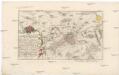
Plan der Stadt und Vestung Neiss
1 : 100000 Nysa (Polsko) auf Kosten der Raspischen Buchhandlung
Zuckmantel - m3594-2-005 - Kaiserpflichtexemplar der Landkarten des stabilen Katasters
1 : 2880
Zuckmantel - m3594-2-002 - Kaiserpflichtexemplar der Landkarten des stabilen Katasters
1 : 2880
Zuckmantel - m3594-2-007 - Kaiserpflichtexemplar der Landkarten des stabilen Katasters
1 : 2880
Zuckmantel - m3594-2-004 - Kaiserpflichtexemplar der Landkarten des stabilen Katasters
1 : 2880
Zuckmantel - m3594-2-003 - Kaiserpflichtexemplar der Landkarten des stabilen Katasters
1 : 2880
Zuckmantel - m3594-2-006 - Kaiserpflichtexemplar der Landkarten des stabilen Katasters
1 : 2880