Maps of Koroužné

Kobilnitz - m1228-1-001 - Kaiserpflichtexemplar der Landkarten des stabilen Katasters
1 : 2880
Korouschna (Korožna) - m1276-1-001 - Kaiserpflichtexemplar der Landkarten des stabilen Katasters
1 : 2880
Korouschna (Korožna) - m1276-1-002 - Kaiserpflichtexemplar der Landkarten des stabilen Katasters
1 : 2880

[Gradkartenblatt]
1 : 25000 Bystřice nad Pernštejnem-oblast (Česko) Vojenský zeměpisný ústav
Gradkartenblatt
1 : 25000 Letovice-oblast (Česko) Fromm, Hermann

Brüsau und Gewitsch
1 : 75000 Jevíčko (Česko : oblast) Ansion K. u. k. Militärgeographisches Institut
Brüsau und Gewitsch
1 : 75000 Jevíčko (Česko : oblast) K. u. k. Militärgeographisches Institut
Geologische Spezialkarte der im Reichsrate vertretenen Königreiche und Länder der Österreichisch-Ungarischen Monarchie
1 : 75000 Jevíčko (Česko : oblast) Tietze, Emil Ernst August Lipold, Markus Vincenc K. k. geologischen Reichsanstalt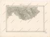
Special - Karte des Koenigreiches Boehmen

Podrobná mapa Království českého
1 : 100000 Bystré (Svitavy, Česko) Srp, Jan Jos. R. Vilímek
Podrobná místopisná mapa Království Českého

Podrobná mapa Markrabství moravského a Vévodství slezkého
1 : 100000 Bystré (Svitavy, Česko) Srp, Jan Jos. R. Vilímek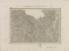
II. vojenské mapování 8
1 : 144000
Boskowitz und Blansko (Mahren).
from Spezialkarte der osterreichisch-ungarischen Monarchie.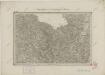
II. vojenské mapování 8
1 : 144000
Brusau und Gewitsch.
from Spezialkarte der osterreichisch-ungarischen Monarchie.
G. Meseritsch.
from Spezialkarte der osterreichisch-ungarischen Monarchie.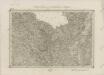
II. vojenské mapování 8
1 : 144000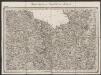
Umgebungen von Neustadtl und Brüsau
1 : 144000 K.K. Militärisches Geographisches Institut
Monumenta Cartographica Bohemiae II.: Müllerova mapa

Generální mapa okresního hejtmanství Brněnského
Mappa geographica regni Bohemiae in duodecim circuloc divisae ... Sectio. XX.
Müllerova mapa Čech
1 : 132000
[Okolí Moravské Třebové
1 : 75000 Letovice (Česko : oblast) Vojenský zeměpisný ústav
Komunikační mapa země Moravskoslezské
1 : 100000 Brno (Česko : oblast) Morslez. zem. výbor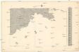
[Nová Mapa království Českého]
1 : 200000 Čechy jihovýchodní (Česko) Kotyška, Václav Hanf, Norbert Bursík & Kohout
Příruční mapa politického okresu Boskovického


