Maps of Brandýs nad Labem-Stará Boleslav

Wrab - c8780-1-001 - Kaiserpflichtexemplar der Landkarten des stabilen Katasters
1 : 2880
Wrab - c8780-1-002 - Kaiserpflichtexemplar der Landkarten des stabilen Katasters
1 : 2880
[Brandýs nad Labem]
Brandýs nad Labem (Česko)
Brandeis - c0458-1-003 - Kaiserpflichtexemplar der Landkarten des stabilen Katasters
1 : 2880
Brandeis - c0458-1-002 - Kaiserpflichtexemplar der Landkarten des stabilen Katasters
1 : 2880
Brandeis - c0458-1-004 - Kaiserpflichtexemplar der Landkarten des stabilen Katasters
1 : 2880
Brandeis - c0458-1-005 - Kaiserpflichtexemplar der Landkarten des stabilen Katasters
1 : 2880
Brandeis - c0458-1-001 - Kaiserpflichtexemplar der Landkarten des stabilen Katasters
1 : 2880
Das Schloß Brandeyß in Böhme[n], vnd verschantzungen des Schwedische[n] Velds, welches Gen. Ban[n]er, vor de[n] kayserischen verlassen, im Martio 1640
Brandýs nad Labem-Stará Boleslav-oblast (Česko) Cappi, Carlo
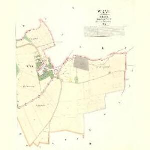
Zaap (Zapi) - c9143-1-001 - Kaiserpflichtexemplar der Landkarten des stabilen Katasters
1 : 2880
Zaap (Zapi) - c9143-1-002 - Kaiserpflichtexemplar der Landkarten des stabilen Katasters
1 : 2880
Zaap (Zapi) - c9143-1-003 - Kaiserpflichtexemplar der Landkarten des stabilen Katasters
1 : 2880
Drzewtschitz (Dřewčice) - c1562-1-001 - Kaiserpflichtexemplar der Landkarten des stabilen Katasters
1 : 2880
Drzewtschitz (Dřewčice) - c1562-1-004 - Kaiserpflichtexemplar der Landkarten des stabilen Katasters
1 : 2880
Drzewtschitz (Dřewčice) - c1562-1-003 - Kaiserpflichtexemplar der Landkarten des stabilen Katasters
1 : 2880
Drzewtschitz (Dřewčice) - c1562-1-002 - Kaiserpflichtexemplar der Landkarten des stabilen Katasters
1 : 2880
Brandeis a. d. Elbe - Altbunzlau (Brandýs nad Labem - Stará Boleslav)

[Brandeis mit seinen Umgebung]
Brandýs nad Labem-Stará Boleslav-oblast (Česko)
Projectierte Lager
1 : 15000 Brandýs nad Labem (Česko)
Mapa politického okresu Mladoboleslavského
Mapa politického a školního okresu Českobrodského

Gradkartenblatt
1 : 25000 Brandýs nad Labem-Stará Boleslav-oblast (Česko) Czechák, Carl
III. vojenské mapování 3953/2
1 : 25000
Bez titulu:Sektion 3953 Brandýs nad Labem, Stará Boleslav

III. vojenské mapování 3953/2
1 : 25000
Mapa půd v okrese Brandýs n./Lab
1 : 38000 Brandýs nad Labem-Stará Boleslav-oblast (Česko) Spirhanzl, J. Srch, J. reprodukce Voj. zeměpisného ústavu
Karte des Brandeiser Bezirkes im Prager Kreise
1 : 70000 Brandýs nad Labem-Stará Boleslav-oblast (Česko) Wagner, Jan Eduard Karl André
Podrobné mapy zemí Koruny české v měřítku 1:75.000 - Praha - Brandýs n. L. Průvodce statisticko-historický po všech místech na těchto mapách uvedených a rejstřík věcný názvů hor, potoků, řek, rybníků atd. a mapa vzdáleností všech míst při silnici ležících Sešit 1. List 55,
1 : 75000