Maps of Jenišovice

Stienitz (Stěnice) - c7768-1-001 - Kaiserpflichtexemplar der Landkarten des stabilen Katasters
1 : 2880
Stienitz (Stěnice) - c7768-1-002 - Kaiserpflichtexemplar der Landkarten des stabilen Katasters
1 : 2880
Katastrální mapa pro obec Štěnec
1 : 2880
Indikační skica mapy stabilního katastru pro obec Štěnec I
1 : 2880
Indikační skica mapy stabilního katastru pro obec Mravín s osadou Popovec
1 : 2880
Indikační skica mapy stabilního katastru pro obec Mravín s osadou Popovec
1 : 2880
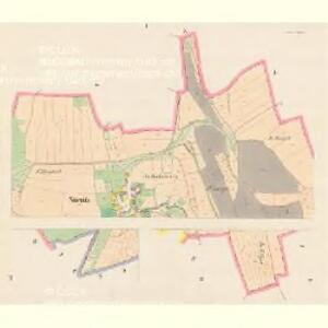
Indikační skica mapy stabilního katastru pro obec Srbce
1 : 2880
Katastrální mapa pro obec Srbce
1 : 2880
Katastrální mapa pro obec Štěnec
1 : 2880
Indikační skica mapy stabilního katastru pro obec Štěnec ad I
1 : 2880
Indikační skica mapy stabilního katastru pro obec Štěnec II; IV
1 : 2880
Indikační skica mapy stabilního katastru pro obec Mravín s osadou Popovec
1 : 2880
Mrawin - c4871-1-001 - Kaiserpflichtexemplar der Landkarten des stabilen Katasters
1 : 2880
Mrawin - c4871-1-003 - Kaiserpflichtexemplar der Landkarten des stabilen Katasters
1 : 2880
Mrawin - c4871-1-002 - Kaiserpflichtexemplar der Landkarten des stabilen Katasters
1 : 2880
Katastrální mapa pro obec Pěšice
1 : 2880
Srbetz - c7191-1-001 - Kaiserpflichtexemplar der Landkarten des stabilen Katasters
1 : 2880
Srbetz - c7191-1-002 - Kaiserpflichtexemplar der Landkarten des stabilen Katasters
1 : 2880
Mapa polesí Luže
1 : 10000
Indikační skica mapy stabilního katastru pro obec Rybitví III.
1 : 2880
Jenschowitz (Jenssowic) - c2840-1-003 - Kaiserpflichtexemplar der Landkarten des stabilen Katasters
1 : 2880
Jenschowitz (Jenssowic) - c2840-1-001 - Kaiserpflichtexemplar der Landkarten des stabilen Katasters
1 : 2880
Jenschowitz (Jenssowic) - c2840-1-002 - Kaiserpflichtexemplar der Landkarten des stabilen Katasters
1 : 2880
Pieschitz - c5755-1-001 - Kaiserpflichtexemplar der Landkarten des stabilen Katasters
1 : 2880
Pieschitz - c5755-1-002 - Kaiserpflichtexemplar der Landkarten des stabilen Katasters
1 : 2880
Indikační skica mapy stabilního katastru pro obec Mravín s osadou Popovec
1 : 2880
Indikační skica mapy stabilního katastru pro obec Mravín s osadou Popovec
1 : 2880
Gradkartenblatt
1 : 25000 Chrast (Chrudim, Česko) Hallada, Alois
III. vojenské mapování 4056/1
1 : 25000