Maps of Stráž

Strachowitz - c7373-1-001 - Kaiserpflichtexemplar der Landkarten des stabilen Katasters
1 : 2880
Strachowitz - c7373-1-002 - Kaiserpflichtexemplar der Landkarten des stabilen Katasters
1 : 2880
Mapa pozemků dvora Vítovice
1 : 2500
Pernartitz - c0126-1-003 - Kaiserpflichtexemplar der Landkarten des stabilen Katasters
1 : 2880
Pernartitz - c0126-1-001 - Kaiserpflichtexemplar der Landkarten des stabilen Katasters
1 : 2880
Pernartitz - c0126-1-002 - Kaiserpflichtexemplar der Landkarten des stabilen Katasters
1 : 2880
Pernartitz - c0126-1-005 - Kaiserpflichtexemplar der Landkarten des stabilen Katasters
1 : 2880
Pernartitz - c0126-1-004 - Kaiserpflichtexemplar der Landkarten des stabilen Katasters
1 : 2880
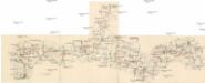
Přehledná porostní mapa borských lesů k lesní prohlídce konané lesnickým spolkem
1 : 10000
Porostní mapa revíru Sedmihoří
1 : 20000
Porostní mapa revíru Olešná
1 : 8640
Porostní mapa revíru Sedmihoří
1 : 10000
Ratzau - c6303-1-004 - Kaiserpflichtexemplar der Landkarten des stabilen Katasters
1 : 2880
Ratzau - c6303-1-001 - Kaiserpflichtexemplar der Landkarten des stabilen Katasters
1 : 2880
Ratzau - c6303-1-002 - Kaiserpflichtexemplar der Landkarten des stabilen Katasters
1 : 2880
Ratzau - c6303-1-003 - Kaiserpflichtexemplar der Landkarten des stabilen Katasters
1 : 2880
Elsch - c5439-1-004 - Kaiserpflichtexemplar der Landkarten des stabilen Katasters
1 : 2880
Elsch - c5439-1-003 - Kaiserpflichtexemplar der Landkarten des stabilen Katasters
1 : 2880
Elsch - c5439-1-001 - Kaiserpflichtexemplar der Landkarten des stabilen Katasters
1 : 2880
Elsch - c5439-1-002 - Kaiserpflichtexemplar der Landkarten des stabilen Katasters
1 : 2880
Wiedlitz - c8564-1-002 - Kaiserpflichtexemplar der Landkarten des stabilen Katasters
1 : 2880
Wiedlitz - c8564-1-003 - Kaiserpflichtexemplar der Landkarten des stabilen Katasters
1 : 2880
Wiedlitz - c8564-1-001 - Kaiserpflichtexemplar der Landkarten des stabilen Katasters
1 : 2880
Mapa revíru Olešná
1 : 2616


III. vojenské mapování 4149
1 : 75000
Politický okres Tachov
1 : 75000 Tachov (Česko : okres : 1960-) Vojenský zeměpisný ústav
Politický okres Tachov