Maps of Horčápsko

Hradek - c7289-1-001 - Kaiserpflichtexemplar der Landkarten des stabilen Katasters
1 : 2880
Hradek - c7289-1-002 - Kaiserpflichtexemplar der Landkarten des stabilen Katasters
1 : 2880
Hradek - c7289-1-003 - Kaiserpflichtexemplar der Landkarten des stabilen Katasters
1 : 2880
Soubor katastrálních map obcí ležících na území velkostatku orlického s přivtělenými statky, s vyznačením příslušné tratě státní dráhy (polohorysy tratí), list 11 list 11
1 : 2880
Tuschowitz - c8130-1-003 - Kaiserpflichtexemplar der Landkarten des stabilen Katasters
1 : 2880
Tuschowitz - c8130-1-002 - Kaiserpflichtexemplar der Landkarten des stabilen Katasters
1 : 2880
Tuschowitz - c8130-1-001 - Kaiserpflichtexemplar der Landkarten des stabilen Katasters
1 : 2880
Horczapsko - c1996-1-003 - Kaiserpflichtexemplar der Landkarten des stabilen Katasters
1 : 2880
Horczapsko - c1996-1-001 - Kaiserpflichtexemplar der Landkarten des stabilen Katasters
1 : 2880
Horczapsko - c1996-1-002 - Kaiserpflichtexemplar der Landkarten des stabilen Katasters
1 : 2880
Mapa porostů panství Tochovice, Březnice a Rožmitála
1 : 17280 Březnice (Příbram, Česko) Schrantz, Fr.
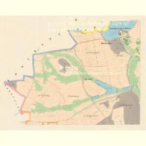
Přehledná mapa pozemkové držby velkostatku orlického v širším pojetí, podle stavu z roku 1916, list 3 1
1 : 25000
Borr - c0357-1-001 - Kaiserpflichtexemplar der Landkarten des stabilen Katasters
1 : 2880
Borr - c0357-1-002 - Kaiserpflichtexemplar der Landkarten des stabilen Katasters
1 : 2880
Tochowitz - c7938-1-002 - Kaiserpflichtexemplar der Landkarten des stabilen Katasters
1 : 2880
Tochowitz - c7938-1-005 - Kaiserpflichtexemplar der Landkarten des stabilen Katasters
1 : 2880
Tochowitz - c7938-1-004 - Kaiserpflichtexemplar der Landkarten des stabilen Katasters
1 : 2880
Tochowitz - c7938-1-003 - Kaiserpflichtexemplar der Landkarten des stabilen Katasters
1 : 2880
Tochowitz - c7938-1-006 - Kaiserpflichtexemplar der Landkarten des stabilen Katasters
1 : 2880
Tochowitz - c7938-1-001 - Kaiserpflichtexemplar der Landkarten des stabilen Katasters
1 : 2880
Nestraschowitz - c5063-1-002 - Kaiserpflichtexemplar der Landkarten des stabilen Katasters
1 : 2880
Nestraschowitz - c5063-1-001 - Kaiserpflichtexemplar der Landkarten des stabilen Katasters
1 : 2880
Nestraschowitz - c5063-1-003 - Kaiserpflichtexemplar der Landkarten des stabilen Katasters
1 : 2880
Brzezy, Prach[iner] Kr[eis]
1 : 2880 Březnice (Příbram, Česko : oblast)
Přehledná mapa rybníků velkostatku Orlík, list 3 1
General-Mape der Herrschaft Březnic
1 : 34560 Březnice (Příbram, Česko : oblast)
III. vojenské mapování 4152/3
1 : 25000
Gradkartenblatt
1 : 25000 Březnice-oblast (Příbram, Česko) Siglitz, Franz
Přehlední [sic] mapa velkostatků Tochovice, Břežnice Rožmitál
1 : 50000 Březnice (Příbram, Česko) Schrantz, Fr.