Maps of Zbrašín

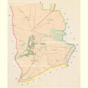
Senkow - c6846-1-001 - Kaiserpflichtexemplar der Landkarten des stabilen Katasters
1 : 2880
Senkow - c6846-1-002 - Kaiserpflichtexemplar der Landkarten des stabilen Katasters
1 : 2880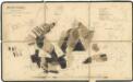
Porostní mapa polesí Selmice 1
1 : 10000
Lischtian (Lisstian) - c4151-1-003 - Kaiserpflichtexemplar der Landkarten des stabilen Katasters
1 : 2880
Lischtian (Lisstian) - c4151-1-004 - Kaiserpflichtexemplar der Landkarten des stabilen Katasters
1 : 2880
Lischtian (Lisstian) - c4151-1-002 - Kaiserpflichtexemplar der Landkarten des stabilen Katasters
1 : 2880
Lischtian (Lisstian) - c4151-1-005 - Kaiserpflichtexemplar der Landkarten des stabilen Katasters
1 : 2880
Lischtian (Lisstian) - c4151-1-001 - Kaiserpflichtexemplar der Landkarten des stabilen Katasters
1 : 2880
Praschin - c9192-1-003 - Kaiserpflichtexemplar der Landkarten des stabilen Katasters
1 : 2880
Praschin - c9192-1-004 - Kaiserpflichtexemplar der Landkarten des stabilen Katasters
1 : 2880
Praschin - c9192-1-001 - Kaiserpflichtexemplar der Landkarten des stabilen Katasters
1 : 2880
Praschin - c9192-1-002 - Kaiserpflichtexemplar der Landkarten des stabilen Katasters
1 : 2880
Brzinkow (Břinkow) - c0613-1-001 - Kaiserpflichtexemplar der Landkarten des stabilen Katasters
1 : 2880
Brzinkow (Břinkow) - c0613-1-004 - Kaiserpflichtexemplar der Landkarten des stabilen Katasters
1 : 2880
Brzinkow (Břinkow) - c0613-1-003 - Kaiserpflichtexemplar der Landkarten des stabilen Katasters
1 : 2880
Brzinkow (Břinkow) - c0613-1-002 - Kaiserpflichtexemplar der Landkarten des stabilen Katasters
1 : 2880
Brodetz (Brodec) - c0521-1-002 - Kaiserpflichtexemplar der Landkarten des stabilen Katasters
1 : 2880
Brodetz (Brodec) - c0521-1-001 - Kaiserpflichtexemplar der Landkarten des stabilen Katasters
1 : 2880
Hospodářská mapa polesí Selmice, sekce 3 1
1 : 2880
[Kartenblatt]
1 : 25000 Louny (Česko : oblast) Reichsamt für Landesaufnahme
III. vojenské mapování 3851/4
1 : 25000
Gradkartenblatt
1 : 25000 Postoloprty-oblast (Česko) Bellschan, Anton
Přehledná mapa polesí lesního úřadu Domoušice 1
1 : 34560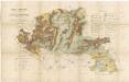
Terénní a půdní mapa pro exkurzi Českého lesnického spolku do domoušického lesního okrsku v roce 1881 1
1 : 30000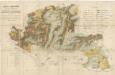
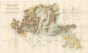
Terénní a půdní mapa pro exkurzi Českého lesnického spolku do domoušického lesního okrsku v roce 1881 1
1 : 30000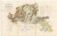
Terénní a půdní mapa pro exkurzi Českého lesnického spolku do domoušického lesního okrsku v roce 1881 1
1 : 30000
Terénní a půdní mapa pro exkurzi Českého lesnického spolku do domoušického lesního okrsku v roce 1881 1
1 : 30000
Přehledná mapa schwarzenberského majetku v severozápadních Čechách po provedení pozemkové reformy 1
1 : 50000