Maps of Louny


Přehledná mapa schwarzenberského majetku v severozápadních Čechách po provedení pozemkové reformy 1
1 : 50000
[Krajina podél Ohře od Postoloprt k Lounům a dále až ke Křtenovu a Chlumčanům]
Louny (Česko : oblast)
III. vojenské mapování 3851/4
1 : 25000
[Kartenblatt]
1 : 25000 Louny (Česko : oblast) Reichsamt für Landesaufnahme
Gradkartenblatt
1 : 25000 Postoloprty-oblast (Česko) Bellschan, Anton
Gradkartenblatt
1 : 25000 Louny-oblast (Česko) Bellschan, Anton
III. vojenské mapování 3852/3
1 : 25000
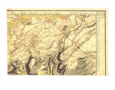
Projectierte Läger bey Laun und den Dorf Neuschloss
1 : 30000 Louny (Česko : oblast)
Žerotin - c9417-1-003 - Kaiserpflichtexemplar der Landkarten des stabilen Katasters
1 : 2880
Žerotin - c9417-1-001 - Kaiserpflichtexemplar der Landkarten des stabilen Katasters
1 : 2880
Žerotin - c9417-1-005 - Kaiserpflichtexemplar der Landkarten des stabilen Katasters
1 : 2880
Žerotin - c9417-1-004 - Kaiserpflichtexemplar der Landkarten des stabilen Katasters
1 : 2880
Žerotin - c9417-1-007 - Kaiserpflichtexemplar der Landkarten des stabilen Katasters
1 : 2880
Žerotin - c9417-1-008 - Kaiserpflichtexemplar der Landkarten des stabilen Katasters
1 : 2880
Žerotin - c9417-1-006 - Kaiserpflichtexemplar der Landkarten des stabilen Katasters
1 : 2880
Žerotin - c9417-1-002 - Kaiserpflichtexemplar der Landkarten des stabilen Katasters
1 : 2880
Plan der zur Hochfürstlich Rudolph Kinskischen Herrschaft Zlonitz gehoerigen Doerfer Billichow mit der Wald-Revier und Klein-Horeschowitz, dann dem Gute Sazena und Mayerhof Nieder-Kam[m]enitz
1 : 19400 Bílichov (Česko) Troesel
[Ohře mezi Lenešicemi a Radonicemi nad Ohří]
Lenešice (Česko)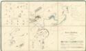
Polesní mapa polesí Postoloprty, druhý exemplář 1

Laun (Launy) - c4258-1-009 - Kaiserpflichtexemplar der Landkarten des stabilen Katasters
1 : 2880
Laun (Launy) - c4258-1-005 - Kaiserpflichtexemplar der Landkarten des stabilen Katasters
1 : 2880
Laun (Launy) - c4258-1-004 - Kaiserpflichtexemplar der Landkarten des stabilen Katasters
1 : 2880
Laun (Launy) - c4258-1-006 - Kaiserpflichtexemplar der Landkarten des stabilen Katasters
1 : 2880
Laun (Launy) - c4258-1-008 - Kaiserpflichtexemplar der Landkarten des stabilen Katasters
1 : 2880
Laun (Launy) - c4258-1-001 - Kaiserpflichtexemplar der Landkarten des stabilen Katasters
1 : 2880
Laun (Launy) - c4258-1-007 - Kaiserpflichtexemplar der Landkarten des stabilen Katasters
1 : 2880
Laun (Launy) - c4258-1-003 - Kaiserpflichtexemplar der Landkarten des stabilen Katasters
1 : 2880
Laun (Launy) - c4258-1-002 - Kaiserpflichtexemplar der Landkarten des stabilen Katasters
1 : 2880