Maps of Radhošť

Sedlischtky - c6805-1-002 - Kaiserpflichtexemplar der Landkarten des stabilen Katasters
1 : 2880
Sedlischtky - c6805-1-001 - Kaiserpflichtexemplar der Landkarten des stabilen Katasters
1 : 2880
Katastrální mapa pro obec Trusnov a osady Franclinu a Žiku
1 : 2880
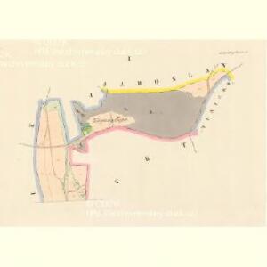
Mapa rozparcelovaných pozemků vrchnostenského dvora v Radhošti
1 : 3000
Katastrální mapa pro obec Radhošť
1 : 2880
Indikační skica mapy stabilního katastru pro obec Radhošť
1 : 2880
Katastrální mapa pro obec Radhošť
1 : 2880
Indikační skica mapy stabilního katastru pro obec Stradouň ad I
1 : 2880
Indikační skica mapy stabilního katastru pro obec Stradouň
1 : 2880
Mapa pozemků a drenáže vrchnostenského dvora v Radhošti
1 : 2880
Trusnow - c8006-1-001 - Kaiserpflichtexemplar der Landkarten des stabilen Katasters
1 : 2880
Trusnow - c8006-1-003 - Kaiserpflichtexemplar der Landkarten des stabilen Katasters
1 : 2880
Trusnow - c8006-1-004 - Kaiserpflichtexemplar der Landkarten des stabilen Katasters
1 : 2880
Trusnow - c8006-1-002 - Kaiserpflichtexemplar der Landkarten des stabilen Katasters
1 : 2880
Radhoscht (Radhosst) - c6342-1-002 - Kaiserpflichtexemplar der Landkarten des stabilen Katasters
1 : 2880
Radhoscht (Radhosst) - c6342-1-001 - Kaiserpflichtexemplar der Landkarten des stabilen Katasters
1 : 2880
Indikační skica mapy stabilního katastru pro obec Opočno
1 : 2880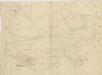
Indikační skica mapy stabilního katastru pro obec Radhošť
1 : 2880
Indikační skica mapy stabilního katastru pro obec Opočno
1 : 2880
Opotschno (Opočno) - c5500-1-001 - Kaiserpflichtexemplar der Landkarten des stabilen Katasters
1 : 2880
Opotschno (Opočno) - c5500-1-002 - Kaiserpflichtexemplar der Landkarten des stabilen Katasters
1 : 2880
Mapa pozemků vrchnostenského dvora Malejov na chroustovickém panství
1 : 2880
Mapa polesí Uhersko - sever
1 : 10000
Indikační skica mapy stabilního katastru pro obec Týníšťko
1 : 2880
Mapa polesí Uhersko
1 : 10000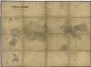
Porostní mapa polesí Uhersko
1 : 10000
Indikační skica mapy stabilního katastru pro obec Trusnov a osadu Žíku
1 : 2880
Hospodářská mapa polesí Uhersko
1 : 5000
Stradaun - c7369-1-004 - Kaiserpflichtexemplar der Landkarten des stabilen Katasters
1 : 2880
Stradaun - c7369-1-001 - Kaiserpflichtexemplar der Landkarten des stabilen Katasters
1 : 2880
Stradaun - c7369-1-003 - Kaiserpflichtexemplar der Landkarten des stabilen Katasters
1 : 2880