Maps of Řepníky

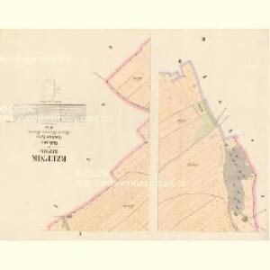
Rzepnik (Řepnik) - c6698-1-001 - Kaiserpflichtexemplar der Landkarten des stabilen Katasters
1 : 2880
Rzepnik (Řepnik) - c6698-1-004 - Kaiserpflichtexemplar der Landkarten des stabilen Katasters
1 : 2880
Rzepnik (Řepnik) - c6698-1-003 - Kaiserpflichtexemplar der Landkarten des stabilen Katasters
1 : 2880
Rzepnik (Řepnik) - c6698-1-002 - Kaiserpflichtexemplar der Landkarten des stabilen Katasters
1 : 2880
Katastrální mapa pro obec Pěšice
1 : 2880
Strzemoschitz (Střemossic) - c7455-1-003 - Kaiserpflichtexemplar der Landkarten des stabilen Katasters
1 : 2880
Strzemoschitz (Střemossic) - c7455-1-002 - Kaiserpflichtexemplar der Landkarten des stabilen Katasters
1 : 2880
Strzemoschitz (Střemossic) - c7455-1-001 - Kaiserpflichtexemplar der Landkarten des stabilen Katasters
1 : 2880
Pustina - c6288-1-002 - Kaiserpflichtexemplar der Landkarten des stabilen Katasters
1 : 2880
Pustina - c6288-1-001 - Kaiserpflichtexemplar der Landkarten des stabilen Katasters
1 : 2880
Katastrální mapa pro obec Voletice a osadu Domanice
1 : 2880
Mapa polesí Luže
1 : 10000
Mapa cest a silnic polesí Košumberk
1 : 10000
Indikační skica mapy stabilního katastru pro obec Voletice a osadu Domanice
1 : 2880
Liebezina (Liebecina) - c3983-1-003 - Kaiserpflichtexemplar der Landkarten des stabilen Katasters
1 : 2880
Liebezina (Liebecina) - c3983-1-001 - Kaiserpflichtexemplar der Landkarten des stabilen Katasters
1 : 2880
Liebezina (Liebecina) - c3983-1-002 - Kaiserpflichtexemplar der Landkarten des stabilen Katasters
1 : 2880
Swarzen (Swařen) - c7580-1-003 - Kaiserpflichtexemplar der Landkarten des stabilen Katasters
1 : 2880
Swarzen (Swařen) - c7580-1-001 - Kaiserpflichtexemplar der Landkarten des stabilen Katasters
1 : 2880
Swarzen (Swařen) - c7580-1-002 - Kaiserpflichtexemplar der Landkarten des stabilen Katasters
1 : 2880
Pieschitz - c5755-1-001 - Kaiserpflichtexemplar der Landkarten des stabilen Katasters
1 : 2880
Pieschitz - c5755-1-002 - Kaiserpflichtexemplar der Landkarten des stabilen Katasters
1 : 2880
Wolletitz (Wolletic) - c8760-1-003 - Kaiserpflichtexemplar der Landkarten des stabilen Katasters
1 : 2880
Wolletitz (Wolletic) - c8760-1-001 - Kaiserpflichtexemplar der Landkarten des stabilen Katasters
1 : 2880
Wolletitz (Wolletic) - c8760-1-002 - Kaiserpflichtexemplar der Landkarten des stabilen Katasters
1 : 2880
Katastrální mapa pro obec Srbce
1 : 2880
Mapa košumberského revíru
1 : 3650
Mapa dominikálních pozemků panství Košumberk
1 : 2634
Indikační skica mapy stabilního katastru pro obec Srbce
1 : 2880
Koschumberg - c3409-1-001 - Kaiserpflichtexemplar der Landkarten des stabilen Katasters
1 : 2880