Maps of Petrovice u Sušice

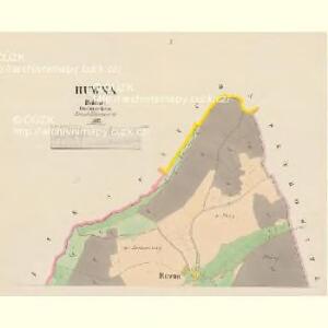
Ruwna - c6575-1-002 - Kaiserpflichtexemplar der Landkarten des stabilen Katasters
1 : 2880
Ruwna - c6575-1-001 - Kaiserpflichtexemplar der Landkarten des stabilen Katasters
1 : 2880
Kochanow - c1310-1-001 - Kaiserpflichtexemplar der Landkarten des stabilen Katasters
1 : 2880
Gaberle - c2802-1-001 - Kaiserpflichtexemplar der Landkarten des stabilen Katasters
1 : 2880
Gaberle - c2802-1-002 - Kaiserpflichtexemplar der Landkarten des stabilen Katasters
1 : 2880
Zikau - c9310-1-001 - Kaiserpflichtexemplar der Landkarten des stabilen Katasters
1 : 2880
Petrowitz - c5736-1-004 - Kaiserpflichtexemplar der Landkarten des stabilen Katasters
1 : 2880
Petrowitz - c5736-1-005 - Kaiserpflichtexemplar der Landkarten des stabilen Katasters
1 : 2880
Petrowitz - c5736-1-001 - Kaiserpflichtexemplar der Landkarten des stabilen Katasters
1 : 2880
Petrowitz - c5736-1-002 - Kaiserpflichtexemplar der Landkarten des stabilen Katasters
1 : 2880
Petrowitz - c5736-1-003 - Kaiserpflichtexemplar der Landkarten des stabilen Katasters
1 : 2880
Sucha - c7539-1-001 - Kaiserpflichtexemplar der Landkarten des stabilen Katasters
1 : 2880
Zamischl (Zamissel) - c9142-1-001 - Kaiserpflichtexemplar der Landkarten des stabilen Katasters
1 : 2880
Zamischl (Zamissel) - c9142-1-002 - Kaiserpflichtexemplar der Landkarten des stabilen Katasters
1 : 2880
[Kartenblatt]
1 : 25000 Hartmanice (Klatovy, Česko : oblast) Reichsamt für Landesaufnahme
III. vojenské mapování 4351/1
1 : 25000
[Mapový list]
1 : 25000 Kašperské Hory-oblast (Česko) Vojenský zeměpisný ústav
Gradkartenblatt
1 : 25000 Kašperské Hory-oblast (Česko) Gerstner, Eduard von
Hospodářská mapa revíru Číhaň
1 : 2918
Mapa Železnorudska

Mapy plánování ČSR

Mapa Šumavy
1 : 50000 Královský Hvozd (Česko) KČST
III. vojenské mapování 4351
1 : 75000
Schüttenhofen und Winterberg
1 : 75000 Sušice (Klatovy, Česko : oblast) K. u. k. Militärgeographisches Institut
Podrobná mapa Království českého
1 : 100000 Sušice (Klatovy, Česko : oblast) Srp, Jan Jaroslav Bursík
Podrobná místopisná mapa Království Českého

Okresní hejtmanství Klatovské
1 : 100000 Klatovy-oblast (Česko) Srp, Jan Jos. R. Vilímek
Schuttenhofen und Winterberg.
from Spezialkarte der osterreichisch-ungarischen Monarchie.