Maps of Šemnice

Pullwitz - c6282-1-001 - Kaiserpflichtexemplar der Landkarten des stabilen Katasters
1 : 2880
Pullwitz - c6282-1-002 - Kaiserpflichtexemplar der Landkarten des stabilen Katasters
1 : 2880
Rittersgrün - c5197-2-001 - Kaiserpflichtexemplar der Landkarten des stabilen Katasters
1 : 2880
Rittersgrün - c5197-2-002 - Kaiserpflichtexemplar der Landkarten des stabilen Katasters
1 : 2880
Ellm - c7377-2-003 - Kaiserpflichtexemplar der Landkarten des stabilen Katasters
1 : 2880
Ellm - c7377-2-001 - Kaiserpflichtexemplar der Landkarten des stabilen Katasters
1 : 2880
Ellm - c7377-2-002 - Kaiserpflichtexemplar der Landkarten des stabilen Katasters
1 : 2880
Ellm - c7377-2-004 - Kaiserpflichtexemplar der Landkarten des stabilen Katasters
1 : 2880
Haid - c0358-1-004 - Kaiserpflichtexemplar der Landkarten des stabilen Katasters
1 : 2880
Haid - c0358-1-002 - Kaiserpflichtexemplar der Landkarten des stabilen Katasters
1 : 2880
Haid - c0358-1-001 - Kaiserpflichtexemplar der Landkarten des stabilen Katasters
1 : 2880
Haid - c0358-1-003 - Kaiserpflichtexemplar der Landkarten des stabilen Katasters
1 : 2880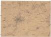
[Kutná Hora a okolí]
Kutná Hora-oblast (Česko) Platzer, Thaddaeus Schäfler, J.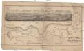
Promenaden-Plan von Carlsbad zur König Otto's Quelle
Karlovy Vary (Česko) Schäfler, J. Gebr. Franieck

Karlsbader Bezirkskarte
1 : 75000 Karlovy Vary-oblast (Česko) Kutschera, G. G. Kutschera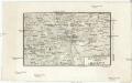
Karlsbad
1 : 220000 Karlovy Vary-oblast (Česko) Streit, Friedrich Wilhelm Müller, Leopold
Luditzer Vikariat
Žlutice-oblast (Česko)
Lichtenstädter Vikariat
Hroznětín (Karlovy Vary, Česko)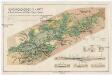
Montangeologische Karte der Braunkohlenreviere von Falkenau, Elbogen u. Karlsbad
1 : 50000 Karlovy Vary (Česko : oblast) Frieser, Antonín Adolf Becker
Montangeologische Karte der Braunkohlenreviere von Falkenau, Elbogen u[nd] Karlsbad
1 : 50000 Karlovy Vary (Česko : oblast) Frieser, Anton Adolf Becker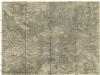
Ostrov u Karlových Varů a okolí
1 : 75000 Karlovy Vary (Česko : oblast) Vojenský zeměpisný ústav
Podrobná mapa Království českého
1 : 100000 Jáchymov (Karlovy Vary, Česko : oblast) Srp, Jan Jos. R. Vilímek
Karlovy Vary
1 : 75000 Karlovy Vary-oblast (Česko) Vojenský zeměpisný ústav
[Vilímkovy místopisné mapy zemí Koruny české]
1 : 100000 Jáchymov (Karlovy Vary, Česko : oblast) Srp, Jan Jos. R. Vilímek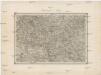
Umgebungen von Lubenz
Lubenec-oblast (Česko) Kiss, Josef K. u. k. Militärgeographisches Institut
Kaaden und St. Joachimsthal.
from Spezialkarte der osterreichisch-ungarischen Monarchie.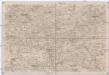
Umgebungen von Lubenz
1 : 750000 Lubenec (Česko : oblast) K. k. militär-geographisches Institut
Karlsbad und Luditz.
from Spezialkarte der osterreichisch-ungarischen Monarchie.


