Maps of Bezvěrov

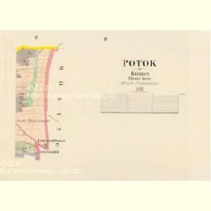
Potok - c6049-1-001 - Kaiserpflichtexemplar der Landkarten des stabilen Katasters
1 : 2880
Potok - c6049-1-002 - Kaiserpflichtexemplar der Landkarten des stabilen Katasters
1 : 2880
Hurz (Horecz) - c9262-1-001 - Kaiserpflichtexemplar der Landkarten des stabilen Katasters
1 : 2880
Hurz (Horecz) - c9262-1-003 - Kaiserpflichtexemplar der Landkarten des stabilen Katasters
1 : 2880
Hurz (Horecz) - c9262-1-002 - Kaiserpflichtexemplar der Landkarten des stabilen Katasters
1 : 2880
Wilkischau (Wlkosow) - c8697-1-002 - Kaiserpflichtexemplar der Landkarten des stabilen Katasters
1 : 2880
Wilkischau (Wlkosow) - c8697-1-001 - Kaiserpflichtexemplar der Landkarten des stabilen Katasters
1 : 2880
Wilkischau (Wlkosow) - c8697-1-003 - Kaiserpflichtexemplar der Landkarten des stabilen Katasters
1 : 2880
Krasch (Krocze) - c3534-1-001 - Kaiserpflichtexemplar der Landkarten des stabilen Katasters
1 : 2880
Krasch (Krocze) - c3534-1-003 - Kaiserpflichtexemplar der Landkarten des stabilen Katasters
1 : 2880
Krasch (Krocze) - c3534-1-002 - Kaiserpflichtexemplar der Landkarten des stabilen Katasters
1 : 2880

Teusinger Vikariat
Toužim-oblast (Česko)
Karlovy Vary
1 : 75000 Karlovy Vary-oblast (Česko) Vojenský zeměpisný ústav
III. vojenské mapování 3950
1 : 75000
Umgebungen von Lubenz
Lubenec-oblast (Česko) Kiss, Josef K. u. k. Militärgeographisches Institut
Tepl und Tuschkau.
from Spezialkarte der osterreichisch-ungarischen Monarchie.
Umgebungen von Lubenz
1 : 750000 Lubenec (Česko : oblast) K. k. militär-geographisches Institut
Karlsbad und Luditz.
from Spezialkarte der osterreichisch-ungarischen Monarchie.
II. vojenské mapování 12
1 : 144000
Generalkarte der Bezirkshauptmannschaft Karlsbad
1 : 220000 Karlovy Vary-oblast (Česko) Wagner, Jan Eduard Mareš, František F. Kytka
Generalkarte der Bezirkshauptmannschaft Karlsbad
1 : 220000 Karlovy Vary-oblast (Česko) Wagner, Jan Eduard F. Kytka
Generalkarte der Bezirkshauptmannschaft Karlsbad
1 : 220000 Karlovy Vary-oblast (Česko) Wagner, Jan Eduard F. Kytka
Generalkarte der Bezirkshauptmannschaft Mies
1 : 220000 Stříbro-oblast (Česko) Wagner, Jan Eduard F. Kytka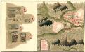
Plan Deren Bergwerg Von Zin Bei Stirn Und Drosau An Tepla Flus
Mollova mapová sbírka Geyer
Generalkarte der Bezirkshauptmannschaft Tepl
1 : 220000 Teplá-oblast (Cheb, Česko) Wagner, Jan Eduard F. Kytka
Generální mapa okresních hejtmanství

Generalkarte der Bezirkshauptmannschaft Podersam
1 : 220000 Podbořany-oblast (Česko) Wagner, Jan Eduard Mareš, František F. Kytka
Turistická mapa okolí Plzně
1 : 75000 Plzeň-oblast (Česko) Vojenský zeměpisný ústav