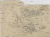
Maps of Jeníkov

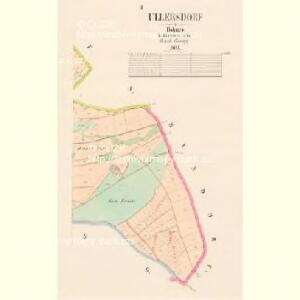
Ullersdorf - c5414-1-002 - Kaiserpflichtexemplar der Landkarten des stabilen Katasters
1 : 2880
Ullersdorf - c5414-1-001 - Kaiserpflichtexemplar der Landkarten des stabilen Katasters
1 : 2880
Geologische und Gruben-Revier-Karte des Kohlenbeckens von Teplitz-Dux-Brüx
1 : 10000 Blatt 10 Wolf, Heinrich Lithografie u. Schnell-Pressen-Druck des k.k. Militär-geografischen Institutes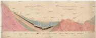
Profil k vysvětlení příhody Teplicko-Osecké
Osek-oblast (Teplice, Česko) Kořistka, Karel František Edvard
Janigg - c2830-1-002 - Kaiserpflichtexemplar der Landkarten des stabilen Katasters
1 : 2880
Janigg - c2830-1-001 - Kaiserpflichtexemplar der Landkarten des stabilen Katasters
1 : 2880
Janigg - c2830-1-003 - Kaiserpflichtexemplar der Landkarten des stabilen Katasters
1 : 2880
Hundorf - c2413-1-002 - Kaiserpflichtexemplar der Landkarten des stabilen Katasters
1 : 2880
Hundorf - c2413-1-001 - Kaiserpflichtexemplar der Landkarten des stabilen Katasters
1 : 2880
Wernsdorf - c8485-1-002 - Kaiserpflichtexemplar der Landkarten des stabilen Katasters
1 : 2880
Wernsdorf - c8485-1-001 - Kaiserpflichtexemplar der Landkarten des stabilen Katasters
1 : 2880
Hegeholz - c1757-4-002 - Kaiserpflichtexemplar der Landkarten des stabilen Katasters
1 : 2880
Hegeholz - c1757-4-001 - Kaiserpflichtexemplar der Landkarten des stabilen Katasters
1 : 2880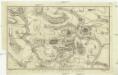
Plan der Gegend bey Töplitz in Böheim
1 : 32000 Teplice-oblast (Česko)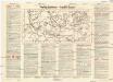
Teplitz-Schönau
Teplice (Česko : oblast) Weber-Ostwalden
Teplitz
Geologischer Atlas zur Naturgeschichte der Erde Leonhard, Carl Cäsar von E. Schweizerbart'sche Verlagsbuchhandlung
III. vojenské mapování 3751/2
1 : 25000
[Kartenblatt]
1 : 25000 Dubí (Teplice, Česko : oblast) Reichsamt für Landesaufnahme
III. vojenské mapování 3751/2
1 : 25000
III. vojenské mapování 3751/2
1 : 25000
III. vojenské mapování 3751/2
1 : 25000
Karte einiger zur Duxer. k. k. priv. Zuckerfabrik gehörigen Meierhöfe und Wirtschaften
Duchcov-oblast (Česko)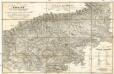
Teplitz mit seinen Umgebungen
1 : 28800 Teplice-oblast (Česko) Stein, Carl
Pohlig's Karte von Teplitz und dessen Umgebung
Teplice-oblast (Česko) J.W. Pohlig
Schlacht bei Kulm am 29ten und 30ten August 1813
Vogel von Falckenstein, Eduard; Brose, Karl Heinrich; Prêtre, Jean Gabriel Pretre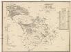
Karte des Bezirkes Dux
1 : 36000 Duchcov-oblast (Česko) Hollmann, Victor Josef Mecséry de Tsóor, Karl Johann Friedrich Selner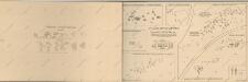
Atlas d'industrie de la république tchécoslovaque

Die Herschaft Toeplitz im Leutmeritzer Creisse des Königreichs Boehmen
1 : 80000 Mollova mapová sbírka Zürner, Adam Friedrich Schenk, Peter II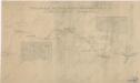
Uibersichtskarte der Aussig Teplitzer Eisenbahn und der in dieselbe einmündenden Zweigbahnen