Maps of Drevníky

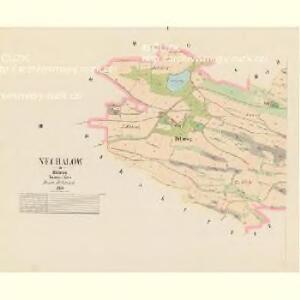
Nechalow - c5010-1-002 - Kaiserpflichtexemplar der Landkarten des stabilen Katasters
1 : 2880
Nechalow - c5010-1-001 - Kaiserpflichtexemplar der Landkarten des stabilen Katasters
1 : 2880
Skallitz (Skalice) - c6912-1-003 - Kaiserpflichtexemplar der Landkarten des stabilen Katasters
1 : 2880
Skallitz (Skalice) - c6912-1-005 - Kaiserpflichtexemplar der Landkarten des stabilen Katasters
1 : 2880
Skallitz (Skalice) - c6912-1-001 - Kaiserpflichtexemplar der Landkarten des stabilen Katasters
1 : 2880
Skallitz (Skalice) - c6912-1-006 - Kaiserpflichtexemplar der Landkarten des stabilen Katasters
1 : 2880
Skallitz (Skalice) - c6912-1-002 - Kaiserpflichtexemplar der Landkarten des stabilen Katasters
1 : 2880
Skallitz (Skalice) - c6912-1-004 - Kaiserpflichtexemplar der Landkarten des stabilen Katasters
1 : 2880
Drhow - c1529-1-001 - Kaiserpflichtexemplar der Landkarten des stabilen Katasters
1 : 2880
Drhow - c1529-1-003 - Kaiserpflichtexemplar der Landkarten des stabilen Katasters
1 : 2880
Drhow - c1529-1-002 - Kaiserpflichtexemplar der Landkarten des stabilen Katasters
1 : 2880
Lhotta Slowanska - c7049-1-002 - Kaiserpflichtexemplar der Landkarten des stabilen Katasters
1 : 2880
Lhotta Slowanska - c7049-1-001 - Kaiserpflichtexemplar der Landkarten des stabilen Katasters
1 : 2880
Homole - c1985-1-001 - Kaiserpflichtexemplar der Landkarten des stabilen Katasters
1 : 2880
Homole - c1985-1-002 - Kaiserpflichtexemplar der Landkarten des stabilen Katasters
1 : 2880
Gradkartenblatt
1 : 25000 Kamýk nad Vltavou (Česko) Mörk, Wenzel von
III. vojenské mapování 4152/2
1 : 25000
Karte des Dobřischer Bezirkes im Prager Kreise
1 : 7000 Dobříš-oblast (Česko) Wagner, Jan Eduard Karl André
Karte des Dobřischer Bezirkes im Prager Kreise
1 : 7000 Dobříš-oblast (Česko) Wagner, Jan Eduard Karl André

Podrobné mapy zemí Koruny české v měřítku 1:75.000 a mapa vzdáleností všech míst při silnici ležících - Příbram - Dobříš. Průvodce statisticko-historický po všech místech na těchto mapách uvedených a rejstřík věcný názvů hor, potoků, řek, rybníků atd./ Sešit 10. List 43,
1 : 75000
Přehledná mapa vltavské trati Kamýk-Štěchovice
1 : 25000 Kamýk (Česko : vodní nádrž) Ředitelství pro stavbu vodních cest
Soubor map okresů Pražského kraje

Soubor map okresů Pražského kraje

Mapa okresu Příbramského v Pražském kraji

Podrobné mapy zemí Koruny české v měřítku 1:75.000 a mapa vzdáleností všech míst při silnici ležících
1 : 75000 Dobříš (Česko : oblast) Bělohlav, Josef F. Topič
Přibram und Mirowitz
1 : 75000 Mirovice (Česko : oblast) Schill K. u. k. Militärgeographisches Institut
Přibram und Mirowitz
1 : 75000 Mirovice (Česko : oblast) K. u. k. Militärgeographisches Institut
III. vojenské mapování 4152
1 : 75000