Maps of Nový Knín


Soubor map okresů Pražského kraje

Podrobné mapy zemí Koruny české v měřítku 1:75.000 a mapa vzdáleností všech míst při silnici ležících - Příbram - Dobříš. Průvodce statisticko-historický po všech místech na těchto mapách uvedených a rejstřík věcný názvů hor, potoků, řek, rybníků atd./ Sešit 10. List 43,
1 : 75000
Karte des Dobřischer Bezirkes im Prager Kreise
1 : 7000 Dobříš-oblast (Česko) Wagner, Jan Eduard Karl André
Karte des Dobřischer Bezirkes im Prager Kreise
1 : 7000 Dobříš-oblast (Česko) Wagner, Jan Eduard Karl André
III. vojenské mapování 4152/2
1 : 25000
Gradkartenblatt
1 : 25000 Kamýk nad Vltavou (Česko) Mörk, Wenzel von
Gradkartenblatt
1 : 25000 Dobříš-oblast (Česko) Mörk, Wenzel von
III. vojenské mapování 4052/4
1 : 25000
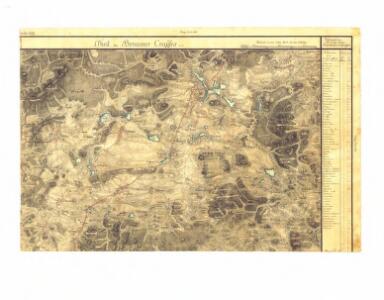
Geognostische Karte der fürstlich Colloredo Mannsfeld'schen Domaine Dobřisch
Dobříš-oblast (Česko) Baumann, Carl Fiscali, Ferdinand
Rosowitz (Rosowice) - c6544-1-008 - Kaiserpflichtexemplar der Landkarten des stabilen Katasters
1 : 2880
Rosowitz (Rosowice) - c6544-1-011 - Kaiserpflichtexemplar der Landkarten des stabilen Katasters
1 : 2880
Rosowitz (Rosowice) - c6544-1-001 - Kaiserpflichtexemplar der Landkarten des stabilen Katasters
1 : 2880
Rosowitz (Rosowice) - c6544-1-010 - Kaiserpflichtexemplar der Landkarten des stabilen Katasters
1 : 2880
Rosowitz (Rosowice) - c6544-1-015 - Kaiserpflichtexemplar der Landkarten des stabilen Katasters
1 : 2880
Rosowitz (Rosowice) - c6544-1-014 - Kaiserpflichtexemplar der Landkarten des stabilen Katasters
1 : 2880
Rosowitz (Rosowice) - c6544-1-005 - Kaiserpflichtexemplar der Landkarten des stabilen Katasters
1 : 2880
Rosowitz (Rosowice) - c6544-1-009 - Kaiserpflichtexemplar der Landkarten des stabilen Katasters
1 : 2880
Rosowitz (Rosowice) - c6544-1-016 - Kaiserpflichtexemplar der Landkarten des stabilen Katasters
1 : 2880
Rosowitz (Rosowice) - c6544-1-013 - Kaiserpflichtexemplar der Landkarten des stabilen Katasters
1 : 2880
Rosowitz (Rosowice) - c6544-1-006 - Kaiserpflichtexemplar der Landkarten des stabilen Katasters
1 : 2880
Rosowitz (Rosowice) - c6544-1-003 - Kaiserpflichtexemplar der Landkarten des stabilen Katasters
1 : 2880
Rosowitz (Rosowice) - c6544-1-012 - Kaiserpflichtexemplar der Landkarten des stabilen Katasters
1 : 2880
Rosowitz (Rosowice) - c6544-1-002 - Kaiserpflichtexemplar der Landkarten des stabilen Katasters
1 : 2880
Rosowitz (Rosowice) - c6544-1-004 - Kaiserpflichtexemplar der Landkarten des stabilen Katasters
1 : 2880
Rosowitz (Rosowice) - c6544-1-007 - Kaiserpflichtexemplar der Landkarten des stabilen Katasters
1 : 2880
Pitschin (Piczin) - c5762-1-008 - Kaiserpflichtexemplar der Landkarten des stabilen Katasters
1 : 2880
Pitschin (Piczin) - c5762-1-004 - Kaiserpflichtexemplar der Landkarten des stabilen Katasters
1 : 2880
Pitschin (Piczin) - c5762-1-001 - Kaiserpflichtexemplar der Landkarten des stabilen Katasters
1 : 2880
Pitschin (Piczin) - c5762-1-002 - Kaiserpflichtexemplar der Landkarten des stabilen Katasters
1 : 2880
Pitschin (Piczin) - c5762-1-007 - Kaiserpflichtexemplar der Landkarten des stabilen Katasters
1 : 2880
Pitschin (Piczin) - c5762-1-003 - Kaiserpflichtexemplar der Landkarten des stabilen Katasters
1 : 2880
Pitschin (Piczin) - c5762-1-009 - Kaiserpflichtexemplar der Landkarten des stabilen Katasters
1 : 2880
Pitschin (Piczin) - c5762-1-006 - Kaiserpflichtexemplar der Landkarten des stabilen Katasters
1 : 2880