Maps of Čakovice

Mischkowitz - c4723-1-001 - Kaiserpflichtexemplar der Landkarten des stabilen Katasters
1 : 2880
Mischkowitz - c4723-1-002 - Kaiserpflichtexemplar der Landkarten des stabilen Katasters
1 : 2880
Výškopisný plán hlavního města Prahy s okolím

Przedletitz - c6223-1-001 - Kaiserpflichtexemplar der Landkarten des stabilen Katasters
1 : 2880
Przedletitz - c6223-1-003 - Kaiserpflichtexemplar der Landkarten des stabilen Katasters
1 : 2880
Przedletitz - c6223-1-002 - Kaiserpflichtexemplar der Landkarten des stabilen Katasters
1 : 2880
Przedletitz - c6223-1-004 - Kaiserpflichtexemplar der Landkarten des stabilen Katasters
1 : 2880
Czakowitz - c0787-1-003 - Kaiserpflichtexemplar der Landkarten des stabilen Katasters
1 : 2880
Czakowitz - c0787-1-002 - Kaiserpflichtexemplar der Landkarten des stabilen Katasters
1 : 2880
Czakowitz - c0787-1-001 - Kaiserpflichtexemplar der Landkarten des stabilen Katasters
1 : 2880
Wellen - c8361-1-004 - Kaiserpflichtexemplar der Landkarten des stabilen Katasters
1 : 2880
Wellen - c8361-1-002 - Kaiserpflichtexemplar der Landkarten des stabilen Katasters
1 : 2880
Wellen - c8361-1-003 - Kaiserpflichtexemplar der Landkarten des stabilen Katasters
1 : 2880
Wellen - c8361-1-001 - Kaiserpflichtexemplar der Landkarten des stabilen Katasters
1 : 2880
Wellen - c8361-1-005 - Kaiserpflichtexemplar der Landkarten des stabilen Katasters
1 : 2880
Trzeboratitz - c8046-1-003 - Kaiserpflichtexemplar der Landkarten des stabilen Katasters
1 : 2880
Trzeboratitz - c8046-1-001 - Kaiserpflichtexemplar der Landkarten des stabilen Katasters
1 : 2880
Trzeboratitz - c8046-1-002 - Kaiserpflichtexemplar der Landkarten des stabilen Katasters
1 : 2880
Projectierte Lager
1 : 15000 Brandýs nad Labem (Česko)
Výškopisný plán hlavního města Prahy s okolím

Výškopisný plán hlavního města Prahy s okolím
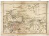
Les environs de Prague
1 : 31000 Praha (Česko)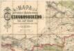
Mapa politického a školního okresu Českobrodského

III. vojenské mapování 3953/1
1 : 25000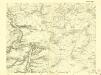
III. vojenské mapování 3953/1
1 : 25000
Gradkartenblatt
1 : 25000 Čechy (Česko) Czechák, Carl
Mapa politického a školního okresu Karlínského


Karte des Brandeiser Bezirkes im Prager Kreise
1 : 70000 Brandýs nad Labem-Stará Boleslav-oblast (Česko) Wagner, Jan Eduard Karl André


