Maps of Šípy

Militschow (Miličow) - c4665-1-001 - Kaiserpflichtexemplar der Landkarten des stabilen Katasters
1 : 2880
Militschow (Miličow) - c4665-1-002 - Kaiserpflichtexemplar der Landkarten des stabilen Katasters
1 : 2880
Militschow (Miličow) - c4665-1-003 - Kaiserpflichtexemplar der Landkarten des stabilen Katasters
1 : 2880
Schippen (Ssippy) - c7732-1-002 - Kaiserpflichtexemplar der Landkarten des stabilen Katasters
1 : 2880
Schippen (Ssippy) - c7732-1-001 - Kaiserpflichtexemplar der Landkarten des stabilen Katasters
1 : 2880
Schippen (Ssippy) - c7732-1-003 - Kaiserpflichtexemplar der Landkarten des stabilen Katasters
1 : 2880
Schippen (Ssippy) - c7732-1-004 - Kaiserpflichtexemplar der Landkarten des stabilen Katasters
1 : 2880
Slatina (Slatyna) - c7005-1-002 - Kaiserpflichtexemplar der Landkarten des stabilen Katasters
1 : 2880
Slatina (Slatyna) - c7005-1-001 - Kaiserpflichtexemplar der Landkarten des stabilen Katasters
1 : 2880
Slatina (Slatyna) - c7005-1-004 - Kaiserpflichtexemplar der Landkarten des stabilen Katasters
1 : 2880
Slatina (Slatyna) - c7005-1-003 - Kaiserpflichtexemplar der Landkarten des stabilen Katasters
1 : 2880
Rothschloss (Czerweny Zamek) - c3488-1-002 - Kaiserpflichtexemplar der Landkarten des stabilen Katasters
1 : 2880
Rothschloss (Czerweny Zamek) - c3488-1-005 - Kaiserpflichtexemplar der Landkarten des stabilen Katasters
1 : 2880
Rothschloss (Czerweny Zamek) - c3488-1-004 - Kaiserpflichtexemplar der Landkarten des stabilen Katasters
1 : 2880
Rothschloss (Czerweny Zamek) - c3488-1-003 - Kaiserpflichtexemplar der Landkarten des stabilen Katasters
1 : 2880
Rothschloss (Czerweny Zamek) - c3488-1-001 - Kaiserpflichtexemplar der Landkarten des stabilen Katasters
1 : 2880
Brzežan - c0609-1-001 - Kaiserpflichtexemplar der Landkarten des stabilen Katasters
1 : 2880
Brzežan - c0609-1-002 - Kaiserpflichtexemplar der Landkarten des stabilen Katasters
1 : 2880
Brzežan - c0609-1-004 - Kaiserpflichtexemplar der Landkarten des stabilen Katasters
1 : 2880
Brzežan - c0609-1-003 - Kaiserpflichtexemplar der Landkarten des stabilen Katasters
1 : 2880
Lhotta - c3919-1-002 - Kaiserpflichtexemplar der Landkarten des stabilen Katasters
1 : 2880
Lhotta - c3919-1-001 - Kaiserpflichtexemplar der Landkarten des stabilen Katasters
1 : 2880


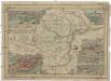
[Umgebung von Kralowitz]
1 : 75000 Kralovice (Plzeň-sever, Česko : oblast) K. u. k. Militärgeographisches Institut
Kralovice a okolí
1 : 75000 Kralovice (Plzeň-sever, Česko : oblast) Vojenský zeměpisný ústav
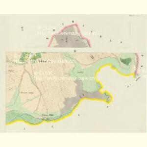
Katastrální mapa obce Kopidlo-Kočín
1 : 2880
General Karte von der hochfürstlich von Metternich'schen Herrschaft Plass mit den vereinten Gütern Katzerow Kraschau u. Biela
1 : 150000 Horní Bělá-oblast (Česko) Wiehl, Anton Metternich, Klemens Wenzel Nepomuk Lothar von
Podrobná mapa Království českého
1 : 100000 Kralovice (Plzeň-sever, Česko : oblast) Srp, Jan Jaroslav Bursík