Maps of Manětín

Podrobná mapa Království českého
1 : 100000 Kralovice (Plzeň-sever, Česko : oblast) Srp, Jan Jaroslav Bursík
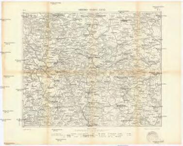
Umgebungen von Lubenz
Lubenec-oblast (Česko) Kiss, Josef K. u. k. Militärgeographisches Institut
III. vojenské mapování 3951
1 : 75000
Mapy plánování ČSR

Podersam und Rakonitz
1 : 75000 Podbořany (Česko : oblast) K. u. k. Militärgeographisches Institut
Podersam und Rakonitz
1 : 75000 Podbořany (Česko : oblast) Hertel, A. K. u. k. militär-geographisches Institut
Podersam und Rakonitz
1 : 75000 Podbořany (Česko : oblast) Hertel, A. K. u. k. Militärgeographisches Institut
Podersam und Rakonitz
1 : 75000 Podbořany (Česko : oblast) K. u. k. Militärgeographisches Institut
Rakovník
1 : 75000 Rakovník-oblast (Česko) Vojenský zeměpisný ústav
Rakovník
1 : 75000 Podbořany (Česko : oblast) Vojenský zeměpisný ústav

Přehledná mapa velkostatku Manětín podle stavu k roku 1905
1 : 37500
Generální mapa panství Plasy se statkem Krašov (bez Kaceřova a Horní Bělé)
1 : 11611
Gradkartenblatt
1 : 25000 Jesenice-oblast (Rakovník, Česko) Bulla, Eduard
III. vojenské mapování 3951/3
1 : 25000
[Kartenblatt]
1 : 25000 Blatno (Louny, Česko) Reichsamt für Landesaufnahme
III. vojenské mapování 3951/1
1 : 25000
Gradkartenblatt
1 : 25000 Podbořany-oblast (Česko) Bulla, Eduard
[Kartenblatt]
1 : 25000 Hořovičky (Česko) Reichsamt für Landesaufnahme
Gradkartenblatt
1 : 25000 Žlutice-oblast (Česko) Brück, Josef
III. vojenské mapování 3950/4
1 : 25000

[Kartenblatt]
1 : 25000 Rabštejn nad Střelou (Manětín, Česko : oblast) Reichsamt für Landesaufnahme
Mapa výhradních kutišť knížete Richarda von Metternich u Žihle
1 : 2918

[Kartenblatt]
1 : 25000 Lubenec (Česko : oblast) Reichsamt für Landesaufnahme
III. vojenské mapování 3950/2
1 : 25000