Maps of Manětín

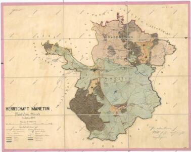
Přehledná mapa velkostatku Manětín podle stavu k roku 1905
1 : 37500

[Kartenblatt]
1 : 25000 Dolní Bělá (Česko : oblast) Reichsamt für Landesaufnahme
III. vojenské mapování 4050/2
1 : 25000
Gradkartenblatt
1 : 25000 Manětín-oblast (Česko) Brzesina, Julius von
Mapa polesí Lomany
1 : 5000
Porostní mapa polesí Lipí
1 : 5760
Mapa části polesí Plasy
1 : 5000
Hospodářská mapa polesí Rabštejn-Kalec
1 : 11520
Rading (Radegow) - c6333-1-006 - Kaiserpflichtexemplar der Landkarten des stabilen Katasters
1 : 2880
Rading (Radegow) - c6333-1-005 - Kaiserpflichtexemplar der Landkarten des stabilen Katasters
1 : 2880
Rading (Radegow) - c6333-1-002 - Kaiserpflichtexemplar der Landkarten des stabilen Katasters
1 : 2880
Rading (Radegow) - c6333-1-007 - Kaiserpflichtexemplar der Landkarten des stabilen Katasters
1 : 2880
Rading (Radegow) - c6333-1-003 - Kaiserpflichtexemplar der Landkarten des stabilen Katasters
1 : 2880
Rading (Radegow) - c6333-1-008 - Kaiserpflichtexemplar der Landkarten des stabilen Katasters
1 : 2880
Rading (Radegow) - c6333-1-001 - Kaiserpflichtexemplar der Landkarten des stabilen Katasters
1 : 2880
Rading (Radegow) - c6333-1-004 - Kaiserpflichtexemplar der Landkarten des stabilen Katasters
1 : 2880
Mapa výhradních kutišť knížete Richarda von Metternich u Žihle
1 : 2918
Katastrální mapa obce Dražeň
1 : 2880
Porostní mapa polesí Lomany
1 : 2918
Porostní mapa polesí Olšany
1 : 2880
Porostní mapa polesí Hůrky
1 : 10000
Porostní mapa polesí Plasy
1 : 2918
Lomiczka (Lomička) - c4221-1-006 - Kaiserpflichtexemplar der Landkarten des stabilen Katasters
1 : 2880
Lomiczka (Lomička) - c4221-1-002 - Kaiserpflichtexemplar der Landkarten des stabilen Katasters
1 : 2880
Lomiczka (Lomička) - c4221-1-004 - Kaiserpflichtexemplar der Landkarten des stabilen Katasters
1 : 2880
Lomiczka (Lomička) - c4221-1-003 - Kaiserpflichtexemplar der Landkarten des stabilen Katasters
1 : 2880
Lomiczka (Lomička) - c4221-1-008 - Kaiserpflichtexemplar der Landkarten des stabilen Katasters
1 : 2880
Lomiczka (Lomička) - c4221-1-007 - Kaiserpflichtexemplar der Landkarten des stabilen Katasters
1 : 2880
Lomiczka (Lomička) - c4221-1-005 - Kaiserpflichtexemplar der Landkarten des stabilen Katasters
1 : 2880