Maps of Čížkov

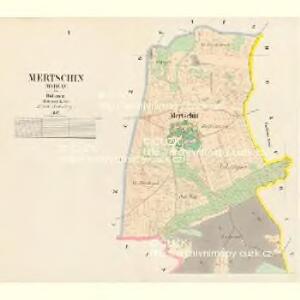
Mertschin (Merčjn) - c4595-1-002 - Kaiserpflichtexemplar der Landkarten des stabilen Katasters
1 : 2880
Mertschin (Merčjn) - c4595-1-001 - Kaiserpflichtexemplar der Landkarten des stabilen Katasters
1 : 2880
Czeczowitz (Čečowice) - c0817-1-002 - Kaiserpflichtexemplar der Landkarten des stabilen Katasters
1 : 2880
Czeczowitz (Čečowice) - c0817-1-001 - Kaiserpflichtexemplar der Landkarten des stabilen Katasters
1 : 2880
Czeczowitz (Čečowice) - c0817-1-003 - Kaiserpflichtexemplar der Landkarten des stabilen Katasters
1 : 2880
Doschitz (Dožice) - c1482-1-003 - Kaiserpflichtexemplar der Landkarten des stabilen Katasters
1 : 2880
Doschitz (Dožice) - c1482-1-002 - Kaiserpflichtexemplar der Landkarten des stabilen Katasters
1 : 2880
Doschitz (Dožice) - c1482-1-001 - Kaiserpflichtexemplar der Landkarten des stabilen Katasters
1 : 2880
Lischkow (Lisskow) - c4141-1-001 - Kaiserpflichtexemplar der Landkarten des stabilen Katasters
1 : 2880
Lischkow (Lisskow) - c4141-1-002 - Kaiserpflichtexemplar der Landkarten des stabilen Katasters
1 : 2880
Przebudow - c6153-1-001 - Kaiserpflichtexemplar der Landkarten des stabilen Katasters
1 : 2880
III. vojenské mapování 4151/4
1 : 25000
Gradkartenblatt
1 : 25000 Spálené Poříčí-oblast (Česko) Böhm, Karl
Mapa okresu Blatenského
1 : 80000 Blatná-oblast (Strakonice, Česko) Rollinger, Jos. Neudörfl, Josef Věnceslav J.V. Neudörfl
Přehlední [sic] mapa velkostatek Rožmital
1 : 50000 Rožmitál pod Třemšínem-oblast (Česko)
Podrobné mapy zemí Koruny české v měřítku 1:75.000 a mapa vzdáleností všech míst při silnici ležících - Blovice - Nepomuk - Blatná. Průvodce statisticko-historický po všech místech na těchto mapách uvedených a rejstřík věcný názvů hor, potoků, řek, rybníků atd. Sešit 42. List 32,
1 : 75000
Plzeň
1 : 75000 Blovice (Česko : oblast) Vojenský zeměpisný ústav
Pilsen und Blowitz
1 : 75000 Blovice (Česko : oblast) Suchánek, F. K. u. k. militär-geographisches Institut
Pilsen und Blowitz
1 : 75000 Blovice (Česko : oblast) Suchánek, F. K. u. k. Militärgeographisches Institut
Pilsen und Blowitz
1 : 75000 Blovice (Česko : oblast) K. u. k. Militärgeographisches Institut
Podrobná mapa Království českého
1 : 100000 Blatná (Strakonice, Česko : oblast) Srp, Jan Jaroslav Bursík
Vilímkovy místopisné mapy zemí Koruny české
1 : 100000 Blatná (Strakonice, Česko) Srp, Jan Jos. R. Vilímek
Podrobná místopisná mapa Království Českého
Příruční mapa Československé republiky

Podrobná místopisná mapa Království Českého

Školní mapa politického okresu Plzeňského

Školní mapa politického okresu Plzeňského

Pilsen und Blowitz.
from Spezialkarte der osterreichisch-ungarischen Monarchie.
Nepomuk und Horazdowitz.
from Spezialkarte der osterreichisch-ungarischen Monarchie.