Maps of Mařenice

Klein Mergthal - c4513-1-002 - Kaiserpflichtexemplar der Landkarten des stabilen Katasters
1 : 2880
Klein Mergthal - c4513-1-001 - Kaiserpflichtexemplar der Landkarten des stabilen Katasters
1 : 2880
Gross Mergthal - c4512-1-003 - Kaiserpflichtexemplar der Landkarten des stabilen Katasters
1 : 2880
Gross Mergthal - c4512-1-005 - Kaiserpflichtexemplar der Landkarten des stabilen Katasters
1 : 2880
Gross Mergthal - c4512-1-004 - Kaiserpflichtexemplar der Landkarten des stabilen Katasters
1 : 2880
Gross Mergthal - c4512-1-002 - Kaiserpflichtexemplar der Landkarten des stabilen Katasters
1 : 2880
Gross Mergthal - c4512-1-001 - Kaiserpflichtexemplar der Landkarten des stabilen Katasters
1 : 2880
Klein Grüne - c1535-2-002 - Kaiserpflichtexemplar der Landkarten des stabilen Katasters
1 : 2880
Klein Grüne - c1535-2-001 - Kaiserpflichtexemplar der Landkarten des stabilen Katasters
1 : 2880
[Kartenblatt]
1 : 25000 Cvikov (Česko : oblast) Reichsamt für Landesaufnahme

III. vojenské mapování 3653/4
1 : 25000
III. vojenské mapování 3653/4
1 : 25000
III. vojenské mapování 3653/4
1 : 25000
III. vojenské mapování 3653/4
1 : 25000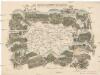
Das böhmisch-sächsische Grenzgebirge
Lužická Nisa-oblast lith. Kunstanstalt von Ed. Strache
Landkreis Böhm[isch] Leipa
1 : 75000 Protektorát Čechy a Morava Dienststelle für Raumordnung und Landesplanung beim Regierungspräsidenten
Varnsdorf
1 : 75000 Cvikov (Česko : oblast) Vojenský zeměpisný ústav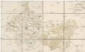
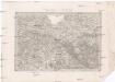
Special Karte des politischen Amtsbezirkes Böhm. Leipa
Česká Lípa-oblast (Česko) Jos. Hamann
Rumburg und Warnsdorf
1 : 75000 Rumburk (Česko : oblast) Lampe K. u. k. militär-geographisches Institut
Rumburg und Warnsdorf
1 : 75000 Rumburk (Česko : oblast) Lampe K. u. k. Militärgeographisches Institut
Rumburg und Warnsdorf
1 : 75000 Rumburk (Česko : oblast) K. u. k. Militärgeographisches Institut
III. vojenské mapování 3653
1 : 75000
Varnsdorf
1 : 75000 Varnsdorf-oblast (Česko) Vojenský zeměpisný ústav
Podrobná mapa Království českého
1 : 100000 Dubá (Česko : oblast) Srp, Jan Jaroslav Bursík
Soubor přehledných map pro plánování a statistiku: Šluknov 3553

Karte des Bezirkes Deutsch-Gabel
1 : 75000 Jablonné v Podještědí-oblast (Česko) Stelzig, Heinrich Freier Lehrervereinim Schulbezirke Deutsch-Gabel
[Umgebung von Gabel]
1 : 78000 Jablonné v Podještědí-oblast (Česko) Kreibich, František Jakub Jindřich
Soubor přehledných map pro plánování a statistiku: 3553 – Šluknov