Maps of okres Česká Lípa

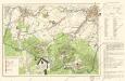
[Umgebung von Gabel]
1 : 78000 Jablonné v Podještědí-oblast (Česko) Kreibich, František Jakub Jindřich
Karte des Bezirkes Deutsch-Gabel
1 : 75000 Jablonné v Podještědí-oblast (Česko) Stelzig, Heinrich Freier Lehrervereinim Schulbezirke Deutsch-Gabel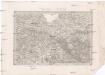
Umgebungen von Reichenberg
1 : 144000 Liberec-oblast (Česko) Baur, A. K. u. k. Militärgeographisches Institut
II. vojenské mapování 3
1 : 144000
II. vojenské mapování 3
1 : 144000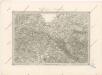
Special - Karte des Koenigreiches Boehmen
Das böhmisch-sächsische Grenzgebirge
Lužická Nisa-oblast lith. Kunstanstalt von Ed. Strache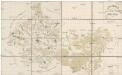
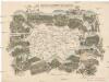
Special Karte des politischen Amtsbezirkes Böhm. Leipa
Česká Lípa-oblast (Česko) Jos. Hamann
Landkreis Böhm[isch] Leipa
1 : 75000 Protektorát Čechy a Morava Dienststelle für Raumordnung und Landesplanung beim Regierungspräsidenten
Rumburg und Warnsdorf
1 : 75000 Rumburk (Česko : oblast) Lampe K. u. k. militär-geographisches Institut
Rumburg und Warnsdorf
1 : 75000 Rumburk (Česko : oblast) Lampe K. u. k. Militärgeographisches Institut
Rumburg und Warnsdorf
1 : 75000 Rumburk (Česko : oblast) K. u. k. Militärgeographisches Institut
Varnsdorf
1 : 75000 Cvikov (Česko : oblast) Vojenský zeměpisný ústav
III. vojenské mapování 3653
1 : 75000

III. vojenské mapování 3653/4
1 : 25000
III. vojenské mapování 3753/2
1 : 25000
III. vojenské mapování 3653/4
1 : 25000
III. vojenské mapování 3653/4
1 : 25000
III. vojenské mapování 3653/4
1 : 25000

[Kartenblatt]
1 : 25000 Mimoň (Česko : oblast) Reichsamt für Landesaufnahme
[Kartenblatt]
1 : 25000 Cvikov (Česko : oblast) Reichsamt für Landesaufnahme
Wanderkarte Zittauer Gebirge

Meßtischblatt 5155.5156 : Oberullersdorf und Markersdorf
1 : 250000 Oberullersdorf und Markersdorf. - Umdr.-Ausg., aufgen. 1903, hrsg. 1905, bericht. 1930, einz. Nachtr. 1936. - 1:25000. - Leipzig, 1938. - 1 Kt.
Meßtischblatt 108.109 : Oberullersdorf und Markersdorf, 1933
1 : 250000 Oberullersdorf und Markersdorf. - Umdr.-Ausg., aufgen. 1903, hrsg. 1905, bericht. 1930. - 1:25000. - Leipzig, 1933. - 1 Kt.
Meßtischblatt 108.109 : Oberullersdorf und Markersdorf, 1921
1 : 250000 Oberullersdorf und Markersdorf. - Aufgen. 1903, hrsg. 1919, einz. Nachtr. 1921. - 1:25000. - Leipzig, 1921. - 1 Kt.
Meßtischblatt 107 : Zittau (Süd), 1933
1 : 250000 Zittau (Süd). - Umdr.-Ausg., aufgen. 1928. - 1:25000. - Leipzig, 1933. - 1 Kt.
Meßtischblatt 107 : Zittau, 1921
1 : 250000 Zittau. - Aufgen. 1899, rev. 1901, hrsg. 1914, einz. Nachtr. 1921. - 1:25000. - Leipzig, 1921. - 1 Kt.
Meßtischblatt 107 : Zittau, 1919
1 : 250000 Zittau. - Aufgen. 1899, rev. 1901, hrsg. 1914, einz. Nachtr. 1919. - 1:25000. - Leipzig, 1919. - 1 Kt.
![[Umgebung von Gabel]](https://images-2.georeferencer.com/images/iiif/400657005679/full/,300/0/native.jpg)

