Maps of Černošice

Lippan - c4098-1-002 - Kaiserpflichtexemplar der Landkarten des stabilen Katasters
1 : 2880
Lippan - c4098-1-001 - Kaiserpflichtexemplar der Landkarten des stabilen Katasters
1 : 2880
Lippan - c4098-1-003 - Kaiserpflichtexemplar der Landkarten des stabilen Katasters
1 : 2880
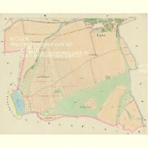
Lippenetz - c4101-1-001 - Kaiserpflichtexemplar der Landkarten des stabilen Katasters
1 : 2880
Lippenetz - c4101-1-002 - Kaiserpflichtexemplar der Landkarten des stabilen Katasters
1 : 2880
Unter-Czernoschitz - c1268-1-002 - Kaiserpflichtexemplar der Landkarten des stabilen Katasters
1 : 2880
Unter-Czernoschitz - c1268-1-001 - Kaiserpflichtexemplar der Landkarten des stabilen Katasters
1 : 2880
Zawobrzesk - c9324-1-002 - Kaiserpflichtexemplar der Landkarten des stabilen Katasters
1 : 2880
Zawobrzesk - c9324-1-001 - Kaiserpflichtexemplar der Landkarten des stabilen Katasters
1 : 2880
Okolí zbraslavské
Zbraslav (Praha, Česko)
[Solopisk und Umgebung]
1 : 9000 Radotín (Praha, Česko) Barrande, Joachim
Radotin - c6394-1-003 - Kaiserpflichtexemplar der Landkarten des stabilen Katasters
1 : 2880
Radotin - c6394-1-005 - Kaiserpflichtexemplar der Landkarten des stabilen Katasters
1 : 2880
Radotin - c6394-1-001 - Kaiserpflichtexemplar der Landkarten des stabilen Katasters
1 : 2880
Radotin - c6394-1-004 - Kaiserpflichtexemplar der Landkarten des stabilen Katasters
1 : 2880
Radotin - c6394-1-002 - Kaiserpflichtexemplar der Landkarten des stabilen Katasters
1 : 2880
Königsaal (Zbraslaw) - c9189-1-001 - Kaiserpflichtexemplar der Landkarten des stabilen Katasters
1 : 2880
Königsaal (Zbraslaw) - c9189-1-002 - Kaiserpflichtexemplar der Landkarten des stabilen Katasters
1 : 2880
III. vojenské mapování 4053/1
1 : 25000
Gradkartenblatt
1 : 25000 Jílové u Prahy-oblast (Česko) Albrecht, Julius

Karte des Königsaaler Bezirkes im Prager Kreise
1 : 71700 Mníšek pod Brdy-oblast (Česko) Wagner, Jan Eduard Karl André
Podrobné mapy zemí Koruny české v měřítku 1:75.000 - Zbraslav - Říčany - Jílové. Průvodce statisticko-historický po všech místech na těchto mapách uvedených a rejstřík věcný názvů hor, potoků, řek, rybníků atd. a mapa vzdáleností všech míst při silnici ležících Sešit 3. List 56,
1 : 75000
Soubor map okresů Pražského kraje

Podrobné mapy zemí Koruny české v měřítku 1:75.000 - Zbraslav - Říčany - Jílové. Průvodce statisticko-historický po všech místech na těchto mapách uvedených a rejstřík věcný názvů hor, potoků, řek, rybníků atd. a mapa vzdáleností všech míst při silnici ležících Sešit 3. List 56,
1 : 75000
Nástin turistických cest
1 : 170000 Praha (Česko : oblast) Hevera, Čeněk KČT
Mapa bývalého dekanátu [sic] Ořechovského
Ořech (Česko) Schmidt, Eduard Winkler, Johann Christoph
Přesná nivelace Velké Prahy s okolím : [přehled nivelačních tratí a osazených výškových bodů]
1 : 25000
Podrobné mapy zemí Koruny české v měřítku 1:75.000 a mapa vzdáleností všech míst při silnici ležících
1 : 75000 Jílové u Prahy (Česko : oblast) Bělohlav, Josef F. Topič