Maps of Úněšov

Woschana - c2456-1-002 - Kaiserpflichtexemplar der Landkarten des stabilen Katasters
1 : 2880
Woschana - c2456-1-003 - Kaiserpflichtexemplar der Landkarten des stabilen Katasters
1 : 2880
Woschana - c2456-1-001 - Kaiserpflichtexemplar der Landkarten des stabilen Katasters
1 : 2880
Skupsch - c6979-1-002 - Kaiserpflichtexemplar der Landkarten des stabilen Katasters
1 : 2880
Skupsch - c6979-1-001 - Kaiserpflichtexemplar der Landkarten des stabilen Katasters
1 : 2880
Skupsch - c6979-1-003 - Kaiserpflichtexemplar der Landkarten des stabilen Katasters
1 : 2880
Anischau - c8254-1-007 - Kaiserpflichtexemplar der Landkarten des stabilen Katasters
1 : 2880
Anischau - c8254-1-002 - Kaiserpflichtexemplar der Landkarten des stabilen Katasters
1 : 2880
Anischau - c8254-1-005 - Kaiserpflichtexemplar der Landkarten des stabilen Katasters
1 : 2880
Anischau - c8254-1-003 - Kaiserpflichtexemplar der Landkarten des stabilen Katasters
1 : 2880
Anischau - c8254-1-004 - Kaiserpflichtexemplar der Landkarten des stabilen Katasters
1 : 2880
Anischau - c8254-1-006 - Kaiserpflichtexemplar der Landkarten des stabilen Katasters
1 : 2880
Anischau - c8254-1-001 - Kaiserpflichtexemplar der Landkarten des stabilen Katasters
1 : 2880
Pichl - c4094-2-002 - Kaiserpflichtexemplar der Landkarten des stabilen Katasters
1 : 2880
Pichl - c4094-2-001 - Kaiserpflichtexemplar der Landkarten des stabilen Katasters
1 : 2880
Malkowitz - c4429-1-001 - Kaiserpflichtexemplar der Landkarten des stabilen Katasters
1 : 2880
Malkowitz - c4429-1-002 - Kaiserpflichtexemplar der Landkarten des stabilen Katasters
1 : 2880
Neschowa - c5168-1-001 - Kaiserpflichtexemplar der Landkarten des stabilen Katasters
1 : 2880

III. vojenské mapování 4050
1 : 75000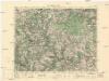
Město Teplá
1 : 75000 Teplá (Cheb, Česko : oblast) Vojenský zeměpisný ústav
Město Teplá
1 : 75000 Teplá-oblast (Cheb, Česko) Vojenský zeměpisný ústav
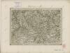
Tepl und Tuschkau
1 : 75000 Město Touškov (Česko : oblast) Bloschitz, Rudolf K. u. k. Militärgeographisches Institut
Tepl und Tuschkau
1 : 75000 Město Touškov-oblast (Česko) K. u. k. Militärgeographisches Institut
Teplá
1 : 75000 Bezdružice (Česko : oblast) Vojenský zeměpisný ústav
Podrobná mapa Království českého
1 : 100000 Plzeň (Česko : oblast) Srp, Jan Jaroslav Bursík
Umgebungskarte von Pilsen

Tepl und Tuschkau.
from Spezialkarte der osterreichisch-ungarischen Monarchie.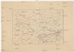
[Okolí Plzně - západ]
Plzeň-oblast (Česko) Krejčí, Jan Schwarzenberg, Bedřich