Maps of Raná

Hradek - c2293-1-001 - Kaiserpflichtexemplar der Landkarten des stabilen Katasters
1 : 2880
Hradek - c2293-1-003 - Kaiserpflichtexemplar der Landkarten des stabilen Katasters
1 : 2880
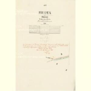
Hradek - c2293-1-002 - Kaiserpflichtexemplar der Landkarten des stabilen Katasters
1 : 2880
Millay (Miley) - c4635-1-001 - Kaiserpflichtexemplar der Landkarten des stabilen Katasters
1 : 2880
Millay (Miley) - c4635-1-002 - Kaiserpflichtexemplar der Landkarten des stabilen Katasters
1 : 2880
Rannay (Rana) - c6430-1-003 - Kaiserpflichtexemplar der Landkarten des stabilen Katasters
1 : 2880
Rannay (Rana) - c6430-1-001 - Kaiserpflichtexemplar der Landkarten des stabilen Katasters
1 : 2880
Rannay (Rana) - c6430-1-004 - Kaiserpflichtexemplar der Landkarten des stabilen Katasters
1 : 2880
Rannay (Rana) - c6430-1-002 - Kaiserpflichtexemplar der Landkarten des stabilen Katasters
1 : 2880
Rannay (Rana) - c6430-1-005 - Kaiserpflichtexemplar der Landkarten des stabilen Katasters
1 : 2880
Weberschan - c0620-1-003 - Kaiserpflichtexemplar der Landkarten des stabilen Katasters
1 : 2880
Weberschan - c0620-1-002 - Kaiserpflichtexemplar der Landkarten des stabilen Katasters
1 : 2880
Weberschan - c0620-1-004 - Kaiserpflichtexemplar der Landkarten des stabilen Katasters
1 : 2880
Weberschan - c0620-1-006 - Kaiserpflichtexemplar der Landkarten des stabilen Katasters
1 : 2880
Weberschan - c0620-1-001 - Kaiserpflichtexemplar der Landkarten des stabilen Katasters
1 : 2880
Weberschan - c0620-1-005 - Kaiserpflichtexemplar der Landkarten des stabilen Katasters
1 : 2880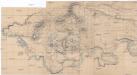
[Ohře mezi Lenešicemi a Radonicemi nad Ohří]
Lenešice (Česko)
Karte des Bezirkes Postelberg
1 : 36000 Postoloprty-oblast (Česko) Hollmann, Victor Josef Mecséry de Tsóor, Karl Johann Friedrich Selner
III. vojenské mapování 3851/2
1 : 25000

[Kartenblatt]
1 : 25000 Bečov (Most, Česko) Reichsamt für Landesaufnahme
[Kartenblatt]
1 : 25000 Bečov (Most, Česko) Reichsamt für Landesaufnahme
Přehledná mapa schwarzenberského majetku v severozápadních Čechách po provedení pozemkové reformy 1
1 : 50000
Lager der Kaÿserl. Königl. Ungarischen Armée beÿ Budin in Böhmen vor der Schlacht beÿ Lowositz Anno 1756
Mollova mapová sbírka Fridrich, Jacob Andreas Friedrich, Jacob Andreas
Přehledná mapa rozptýlených lesů mezi polnostmi lesního úřadu Domoušice 1
1 : 34560
Chomutov
1 : 75000 Chomutov-oblast (Česko) Vojenský zeměpisný ústav
Chomutov
1 : 75000 Chomutov (Česko : oblast) Vojenský zeměpisný ústav
Karte des politischen Amtsbezirkes Teplitz
1 : 105000 Teplice-oblast (Česko) Fleischer, Albin
Saaz und Komotau
1 : 75000 Chomutov (Česko : oblast) Fitz, J. K. u. k. militär-geographisches Institut
Saaz und Komotau
1 : 75000 Chomutov (Česko : oblast) Fitz, J. K. u. k. Militärgeographisches Institut