Maps of Braník

Hotkowiczka - c1931-1-001 - Kaiserpflichtexemplar der Landkarten des stabilen Katasters
1 : 2880
Hotkowiczka - c1931-1-002 - Kaiserpflichtexemplar der Landkarten des stabilen Katasters
1 : 2880
Výškopisný plán hlavního města Prahy s okolím

Orientační plán hlavního města Prahy s okolím
1 : 5000
Lhotka - c3957-1-001 - Kaiserpflichtexemplar der Landkarten des stabilen Katasters
1 : 2880
Lhotka - c3957-1-003 - Kaiserpflichtexemplar der Landkarten des stabilen Katasters
1 : 2880
Lhotka - c3957-1-002 - Kaiserpflichtexemplar der Landkarten des stabilen Katasters
1 : 2880
Orientační plán král. Hl. města Prahy

Plan des südlichen Moldauthal ́s bei Prag

Situační plán stavebních pozemků velkostatku Nový Dvůr u Krče
Nový Dvůr (Praha, Česko) Kebort, I. Neudörfl, Josef Věnceslav Vojenský zeměpisný ústav
Modrzan - c4798-1-004 - Kaiserpflichtexemplar der Landkarten des stabilen Katasters
1 : 2880
Modrzan - c4798-1-005 - Kaiserpflichtexemplar der Landkarten des stabilen Katasters
1 : 2880
Modrzan - c4798-1-001 - Kaiserpflichtexemplar der Landkarten des stabilen Katasters
1 : 2880
Modrzan - c4798-1-002 - Kaiserpflichtexemplar der Landkarten des stabilen Katasters
1 : 2880
Modrzan - c4798-1-003 - Kaiserpflichtexemplar der Landkarten des stabilen Katasters
1 : 2880
Stavební parcely na vily a rodinné domy v Praze XV. - Lhotce-Zátiší na rozhraní Krče a Braníka se rozprodají
Braník (Praha, Česko) Vojenský zeměpisný ústav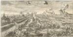
Bestürmbung der Prager Stätte

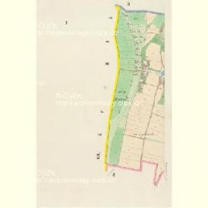
Branik - c0461-1-002 - Kaiserpflichtexemplar der Landkarten des stabilen Katasters
1 : 2880
Branik - c0461-1-003 - Kaiserpflichtexemplar der Landkarten des stabilen Katasters
1 : 2880
Branik - c0461-1-001 - Kaiserpflichtexemplar der Landkarten des stabilen Katasters
1 : 2880
Orientační plán hlavního města Prahy s okolím

Orientační plán hlavního města Prahy s okolím
1 : 5000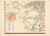
Orientierungsplan der Hauptstadt Prag
Jiřík, Rudolf
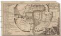
Umgebung von Prag

Prag und seine Umgebungen
Praha (Česko) Bittner, Joseph Kettner, C. J. G. Calvesche Buchhandlung
Nejnovější plán Prahy : připojen abecední seznam ulic k rychlému vyhledávání, seznam škol...
1 : 17500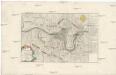
Belagerung und Bloquade der Stadt Prag durch die königl. preussische Armée, im Jahre 1757
Praha (Česko)
Prag und seine Umgebungen, nach den besten Hülfsmitteln dargestellt
1 : 42000 C. Kettner sculp. Prag : J. G. Calve'sche Buchhandlung
Die öffentlichen Verkehrsmittel der Hauptstadt Prag
1 : 17500 Praha (Česko) Městské podniky pražské