Maps of Lažánky

Blattenka - c0267-1-001 - Kaiserpflichtexemplar der Landkarten des stabilen Katasters
1 : 2880
Blattenka - c0267-1-002 - Kaiserpflichtexemplar der Landkarten des stabilen Katasters
1 : 2880
Laschanek - c3822-1-003 - Kaiserpflichtexemplar der Landkarten des stabilen Katasters
1 : 2880
Laschanek - c3822-1-002 - Kaiserpflichtexemplar der Landkarten des stabilen Katasters
1 : 2880
Laschanek - c3822-1-001 - Kaiserpflichtexemplar der Landkarten des stabilen Katasters
1 : 2880
Mratschof (Mračow) - c4866-1-001 - Kaiserpflichtexemplar der Landkarten des stabilen Katasters
1 : 2880
Matschkow (Mačkow) - c4348-1-004 - Kaiserpflichtexemplar der Landkarten des stabilen Katasters
1 : 2880
Matschkow (Mačkow) - c4348-1-001 - Kaiserpflichtexemplar der Landkarten des stabilen Katasters
1 : 2880
Matschkow (Mačkow) - c4348-1-002 - Kaiserpflichtexemplar der Landkarten des stabilen Katasters
1 : 2880
Matschkow (Mačkow) - c4348-1-003 - Kaiserpflichtexemplar der Landkarten des stabilen Katasters
1 : 2880
Gindrzichowitz - c2910-1-002 - Kaiserpflichtexemplar der Landkarten des stabilen Katasters
1 : 2880
Gindrzichowitz - c2910-1-001 - Kaiserpflichtexemplar der Landkarten des stabilen Katasters
1 : 2880
III. vojenské mapování 4252/1
1 : 25000

Gradkartenblatt
1 : 25000 Blatná-oblast (Strakonice, Česko) Albrecht, Julius
III. vojenské mapování 4252/1
1 : 25000
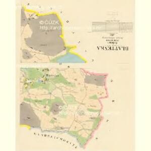
Mapa okresu Blatenského
1 : 80000 Blatná-oblast (Strakonice, Česko) Rollinger, Jos. Neudörfl, Josef Věnceslav J.V. Neudörfl
Pisek und Blatna
1 : 75000 Blatná (Strakonice, Česko : oblast) Petrakovič K. u. k. militär-geographisches Institut
Pisek und Blatna
1 : 75000 Blatná (Strakonice, Česko : oblast) K. u. k. Militärgeographisches Institut
Koenigreich Boehmen...

Písek
1 : 75000 Blatná (Strakonice, Česko : oblast) Vojenský zeměpisný ústav
Písek
1 : 75000 Písek-oblast (Česko) Vojenský zeměpisný ústav
III. vojenské mapování 4252
1 : 75000
Podrobná mapa Království českého
1 : 100000 Blatná (Strakonice, Česko : oblast) Srp, Jan Jaroslav Bursík
Vilímkovy místopisné mapy zemí Koruny české
1 : 100000 Blatná (Strakonice, Česko) Srp, Jan Jos. R. Vilímek
Podrobná místopisná mapa Království Českého

Multiplikáty předcházející mapy, list 1 1

Přehlední mapa panství vorlického [sic]
1 : 75600 Orlík nad Vltavou-oblast (Česko) Waraus, E.
II. vojenské mapování 15
1 : 144000