Maps of Czech Republic

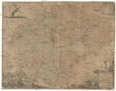
Nova totius Regni Bohemiae tabula
1 : 405000 Česko Vogt, Mauritius Blanck, Ioann. Leon. Ioann Zieger
Nova totius Regni Bohemiae tabula
1 : 405000 Česko Vogt, Mauritius Blanck, Ioann. Leon. Ioann Zieger
Nova totius Regni Bohemiae tabula
1 : 405000 Čechy (Česko) Vogt, Mauritius Blanck, Ioann. Leon. Ioann Zieger
Nova totius Regni Bohemiae tabula
1 : 405000 Česko Vogt, Mauritius Blanck, Ioann. Leon. Ioann Zieger
Charte vom Königreich Böheim
1 : 670000 Čechy (Česko) Güssefeld, Franz L. im Verlage des Industrie Comptoirs
Charte vom Königreich Böheim
1 : 670000 Česko Güssefeld, Franz L. im Verlage des Industrie Comptoirs
Charte vom Königreich Böheim
1 : 670000 Čechy (Česko) Güssefeld, Franz L. im Verlage des Industrie Comptoirs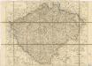
Karte vom Königreiche Böhmen...

České království
1 : 700000
Karte vom Königreich Böheim
1 : 530000 Česko David, Martin Alois von der k. k. privilegirten Schneider und Weigelschen Kunst und Buchhandlung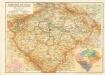
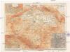
Zeměpisná mapa Čech s hranicemi krajů r. 1654 a hlavními silnicemi

Schulkarte von Böhmen
Země česká
1 : 1000000 Krkonoše (Česko a Polsko) Machát, František V. Neubert a synové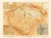
Země Česká

Kreis-, Gerichts-, Völker-, Telegrafen-, Eisenbahn- und Post- Karte des Königreiches Böhmen
1 : 950000 Česko Raffelsperger, Franz Graben
Čechy
1 : 1000000 Krkonoše-oblast (Česko a Polsko) Semík, Matěj
Poštowská mapa králowstwí Českého
1 : 2850000 Čechy (Česko) Dundra, J. A.
Karte vom Königreiche Böhmen
1 : 690000 Česko Carl Wilhelm Medau
Karte vom Königreiche Böhmen
1 : 690000 Česko Carl Wilhelm Medau

Le Royaume de Boheme divisée en ses douze cercles
1 : 700000 Kladsko-oblast (Polsko) Müller, Johann Christoph Covens et Mortier
Kreis-, Gerichts-, Völker-, Telegrafen-, Eisenbahn- und Post-Karte des Königreiches Boehmen
1 : 890000 Česko Raffelsperger, Franz Franz Raffelsperger
Kreis-, Gerichts-, Völker-, Telegrafen-, Eisenbahn- und Post-Karte des Königreiches Boehmen
1 : 890000 Čechy (Česko) Raffelsperger, Franz Franz Raffelsperger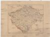
Karte der Verbreitung der Torfmoore in Böhmen
Česko Sitenský, František Ladislav Kořistka, Karel František Edvard
Karte des Königreiches Boehmen
1 : 880000 Čechy (Česko) Raffelsperger, Franz Rumpold, F. im Typographischen Landkarten-Verlage
Mappa totius regni Bohemiae
1 : 700000 Čechy (Česko) Bock-Polach, Josef Ferdinand Müller, Johann Christoph
Mappa totius regni Bohemiae
1 : 700000 Čechy (Česko) Bock-Polach, Josef Ferdinand Ponheimer, Kilian
Carta del regno di Boemia
1 : 530000 Čechy (Česko) Raffelsperger, Franz Raffaelle
Carte du royaume de Boheme
1 : 530000 Čechy (Česko) Raffelsperger, Franz Rumpold, F. François Raffelsperger
Charte von Boehmen
1 : 1030000 Česko