Maps of Central Lowland

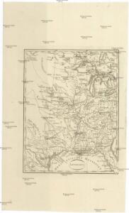
Louisiana
Louisiana
Louisiana
Louisiana
United States of America.
1 : 7603200 Melish, John
Louisiana, Fla., Canada.
1 : 8000000 Bowen, Emanuel
Map of the United States / Euphemia Fenno.
from Whole Euphemia Fenno,
United States of America - Central. Pergamon World Atlas.
1 : 5000000 Polish Army Topography Service
United States of America.
1 : 1960000 Tanner, Henry S.
United States.
1 : 5400000 W. & A.K. Johnston Limited
Colton's New Railroad & County Map Of The United States.
1 : 3041280 Colton, J. H.
Composite: Colton's New Railroad & County Map Of The United States.
1 : 3041280 Colton, J. H.
United States.
1 : 8000000 Teesdale, Henry
Facsimile: Faden's North America (northwestern portion).
1 : 8000000 Faden, William, 1750?-1836

United States.
1 : 5400000 W. & A.K. Johnston Limited
United States.
1 : 5400000 W. & A.K. Johnston Limited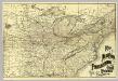
N.Y., Penn. and Ohio R.R.
1 : 6820000 New York, Pennsylvania and Ohio Railroad Company
United States - central section.
1 : 5000000 John Bartholomew & Co.
Pennsylvania RR Great Trunk Line.
1 : 4055000 Rand McNally and Company
United States.
1 : 8400000 Sharpe, J.
States of America, from the best authorities / J. Russell del. et sculp.
from A new geographical, historical, and commercial grammar : and present state of the several kingdoms of the world ... to which are added, I. A geographical index, with the names of places alphabetically arranged ... / by William Guthrie, esq. ; the astronomical parts by James Ferguson, F.R.S. ...
Louisiane, Cours du Mississipi.
1 : 4700000 L'Isle, Guillaume de, 1675-1726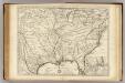
Louisiane, Cours du Mississipi.
1 : 4700000 L'Isle, Guillaume de, 1675-1726
Map of the United States.
1 : 2407680 Robinson, Lewis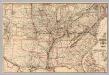
Chesapeake & Ohio Ry.
1 : 6523300 Chesapeake and Ohio Railway Company
Übersichtskarte über die Endmoräne der zweiten Glacialepoche Nord Amerikas nach T. C. Chamberlin 1882
1 : 15000000 gez. v. E. Geinitz aut. v. C. Schmidt Gotha : Perthes
United States of America.
1 : 1960000 Tanner, Henry S.
United States of America.
1 : 1960000 Tanner, Henry S.
Lay's map of the United States / compiled from the latest and best authorities and actual surveys by Amos Lay, geographer and map publisher ; engraved by O.H. & D.S. Throop & Wm. Chapin.
from Whole
United States of America
1 : 2025000
Carte de la Louisiane et du cours du Mississipi dressée sur un grand nombre de memoires entr'autres sur ceux de Mr. le Maire, / par Guillme. de L'Isle de l'Academie Rle. des Sciences.
from Charts and maps Guillaume de l'Isle; Mr. le Maire,
Carte de la Louisiane et du cours du Mississipi dressée sur un grand nombre de memoires entr'autres sur ceux de Mr. le Maire, / par Guillme. de L'Isle de l'Academie Rle. des Sciences.
from Charts and maps Guillaume de l'Isle; Mr. le Maire,