Maps of United States
Norris' Cyclopaedic Map Of The United States Of America.
1 : 9504000 Norris, W.R.
Composite: U.S. West of Mississippi R.
1 : 2000000 Freyhold, Edward; Warren, Gouverneur Kemble, 1830-1882; United States. Army. Corps of Engineers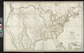
Map of the United States: with the contiguous British & Spanish possessions / compiled from the latest & best authorities by John Melish; engraved by J. Vallance & H.S. Tanner.
from Whole John Melish; J. Vallance; Henry S. Tanner,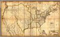
Map of the United States with the contiguous British & Spanish Possessions.
1 : 3900000 Melish, John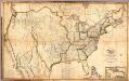
Composite: Map of the United States with the contiguous British & Spanish Possessions.
1 : 3900000 Melish, John
The United States of America / W. Barker sculp., Philadelphia.
from Carey's American pocket atlas; containing nineteen maps... with a brief description of each state.
Population - United States census, 1870. German population. Irish population.
1 : 15000000 Baskin, Forster and Company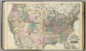
New railroad map of the United States and Cominion of Canada.
1 : 7100000 Baskin, Forster and Company
The United States of America at the time of the ratification of the Constitution, from original maps in the American Geographical Society of New York
1 : 6860480 Map of the United States, with 4 maps of "Claims and cessions of western lands, 1776-1802." In upper margin: "The United States of America at the time of ratification of the Constitution, from original maps in the American Geographical Society of New York and the Library of Congress at Washington. Issued by the United States Sesquicentennial Commission". Include decorative title cartouche and historical notes. Relief shown by hachures. Prime meridian is Philadelphia. Series: "This map is one of a series of similar colored maps, depicting the 13 original states, from New Hampshire to Georgia at the time of the formati John, Mitchel, 1711-1768 Washington, D.C. : United States Constitution Sesquicentennial Commission, [Washington, D.C.] : U.S. Geological Survey
Facsimile: Faden's North America (northwestern portion).
1 : 8000000 Faden, William, 1750?-1836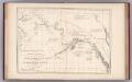
Facsimile: Russian Map (Enclosure in Sir C. Bagot's Dispatch).
1 : 7500000 Alaskan Boundary Tribunal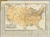
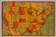
Radio Broadcasting Stations Of The United States.
1 : 8236800 Clason Map Company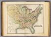
United States.
1 : 8700000 Lizars, Daniel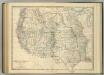
Western United States.
1 : 6047811 Johnston, Alexander Keith
A New Map of The States Of Texas & California
1 : 6652800 Mitchell, Samuel Augustus
Eagle Map of the United States.
1 : 7603200 Moore, I.W.
United States of America.
1 : 11404800 Galveston, Houston, & Henderson Railroad
A New Map of Texas Oregon and California With The Regions Adjoining.
1 : 6652800 Mitchell, Samuel Augustus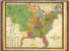
Map of the United States.
1 : 7000000 Mitchell, Samuel Augustus
North America, 1710.
1 : 13500000 Senex, John
Map of the United States: drawn from the most approved surveys / engraved by G.W. Merchant, Albany.
from Whole G. W. Merchant,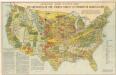
Armour ́s food source map the greatness of the Unitet States is founded on agriculture
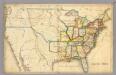
Chicago Milwaukee and St. Paul Ry. and connections.
1 : 4840000 Chicago, Milwaukee, and St. Paul Railway Company
Map Of The United States.
1 : 6000000 Emory, William H.
United States of America / compiled from the latest & best authorities by John Melish; engraved by Saml. Harrison.
from Charts and maps John Melish; Saml. Harrison,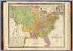
Map of The United States.
1 : 6950000 Finley, Anthony
National Map Of The Territory Of The United States.
1 : 3801600 Keeler, William J.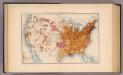
10. Population 1870.
1 : 14000000 Gannett, Henry, 1846-1914; United States. Census Office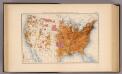
11. Population 1880.
1 : 14000000 Gannett, Henry, 1846-1914; United States. Census Office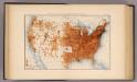
12. Population 1890.
1 : 14000000 Gannett, Henry, 1846-1914; United States. Census Office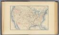
1. Accessions of territory.
1 : 14000000 Gannett, Henry, 1846-1914; United States. Census Office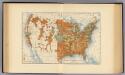
28. Increase 1890 to 1900.
1 : 14000000 Gannett, Henry, 1846-1914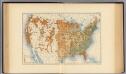
29. Predominating sex.
1 : 14000000 Gannett, Henry, 1846-1914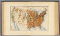
25. Density of increase of population, U.S., 1890-1900.
1 : 14000000 Gannett, Henry, 1846-1914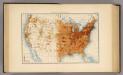
13. Population 1900.
1 : 14000000 Gannett, Henry, 1846-1914; United States. Census Office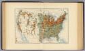
26. Population in cities >2000 inhabitants, 1900.
1 : 14000000 Gannett, Henry, 1846-1914
27. Density, urban, increase, whites, density of increase, foreign born.
1 : 55000000 Gannett, Henry, 1846-1914; United States. Census Office
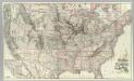
H.H. Lloyd & Co's Campaign Military Charts Showing The Principal Strategic Places Of Interest.
Viele, Egbert L.