Maps of Parndorf/Pandrof
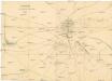
Distanzplan für die Umgebung des Lagers bei Bruck a[n]/L[eitha]
1 : 12500 Bruck an der Leitha (Rakousko)
Plan der Umgebung von Bruck an der Leytha
1 : 29000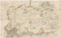
Plan des Cavallerie Manövrir-Rayons bei Parndorf im Jahre 1857
1 : 40000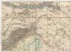
Umgebungs - Karte von Bruck an der Leitha
1 : 75000 Bruck an der Leitha (Rakousko)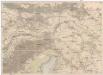
Umgebungs-Karte von Bruck an der Leitha
1 : 75000 Bruck an der Leitha (Rakousko) R. Lechner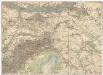
Umgebungs - Karte von Bruck an der Leitha
1 : 75000 Bruck an der Leitha (Rakousko) K. u. K. Militärgeographisches Institut
Moson vármegye
1 : 130000 Neziderské jezero (Maďarsko a Rakousko : oblast) Kováts, János Görög, Demeter Görög
Wienns umgebungen

Gegend um Wien
1 : 336000 Vídeň-oblast (Rakousko) Otto, Johann bey Johann Otto
Comitat Wieselburg
1 : 280000 Mosonmagyaróvár (Maďarsko)
Comitat Wieselburg
1 : 280000
Plan der Gegend zwischen Wien, Neustadt, Presburg und OEdenburg
1 : 243000 Bratislava-oblast (Slovensko) Streit, Friedrich Wilhelm Liechtenstern, Joseph Marx von im Verl. d. Geographishen Instituts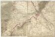
[Wien, Pressburg, Neusiedler See]
1 : 144000 Bratislava-oblast (Slovensko)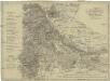
Wien's Umgebung
1 : 270000 Vídeň-oblast (Rakousko) Mollo, Tranquillo Tranquillo Mollo
Wien's Umgebung
1 : 270000 Vídeň-oblast (Rakousko) Mollo, Tranquillo Tranquillo Mollo
Wein. (Nieder-Osterreich)
from Spezialkarte der osterreichisch-ungarischen Monarchie.
Blatt 6 & 11 aus Georg Matthäus Vischer's Archiducatus Austriae inferioris geographica, et noviter emendata accuratissima descriptio
1 : 144000 Rakousko Vischer, Georg Matthaeus K.k. Generalstabes
Mappa Comitatus Mosoniensis
Mollova mapová sbírka Kovács, János Nicolaï, Georg David Christoph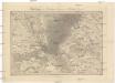
Umgebungen von Hainburg in Oesterreich, und Presburg in Ungarn
1 : 144000 Bratislava-oblast (Slovensko) Müller, A. Withalm, Andreas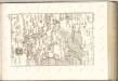

C. Mosoniensis
Ungarn Komitat Moson
Eisenstadt.
from Spezialkarte der osterreichisch-ungarischen Monarchie.
Topographische Karte der Gegenden um Wien seiner kays. Majestät Alexander I. Kayser und Selbstherscher aller Reussen &. &. &. in tiefester Ehrfurcht gewidmet
1 : 100000 Vídeň-oblast (Rakousko) Schmidt, Ludwig Gareis, Joseph bey Johann Cappi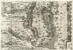
Archiducatus Austriae inferioris Geographica, et Nouiter Emendata Accuratissima Descriptio :
1 : 153333 Mollova mapová sbírka Vischer, Georg Matthaeus Hoffmann, Jakob
Ung. Altenburg.
from Spezialkarte der osterreichisch-ungarischen Monarchie.
Umgebung von Pozsony
1 : 75000 Bratislava (Slovensko : oblast) K. u. k. Militärgeographisches Institut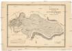
Grundriss der Prädien Hofwiese Mühlwiese und Maulbeer Plantage
1 : 9120 Vídeň-oblast (Rakousko) Kanyo, Michael Cosandier, Ferdinand
Topographische Karte der Gegend von Wien
1 : 93700 Vídeň-oblast (Rakousko) Schmidt, Ludwig Schönberg, Johann bei Johann Schönberg
Umgebung von Poszony

![Distanzplan für die Umgebung des Lagers bei Bruck a[n]/L[eitha]](https://images-2.georeferencer.com/images/iiif/514635364733/full/,300/0/native.jpg)

