Maps of Belgium

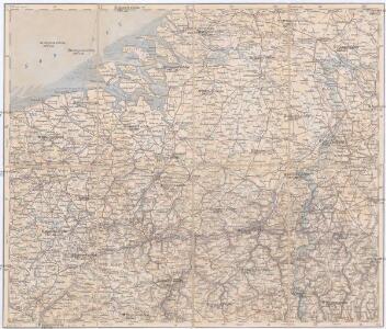
Aachen, Brüssel, St. Quentin
1 : 750000 Brusel (Belgie : oblast) Nicklas, C. K. u. k. Militärgeographisches Institut
Aachen, Brüssel, St. Quentin
1 : 750000 Brusel (Belgie : oblast) K. k. militär-geographisches Institut
Netherlands.
1 : 1190000 Finley, Anthony
Les Provinces des Pays-Bas Catholiques Vulgairement Connües Sous le Nom de Flandre
1 : 800000 Mollova mapová sbírka Sanson, Nicolas Michault, René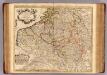
Pays Bas Catholoques.
1 : 700000 L'Isle, Guillaume de, 1675-1726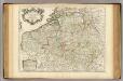
Pays Bas Catholoques.
1 : 700000 L'Isle, Guillaume de, 1675-1726

Netherlands.
1 : 945000 Hall, S. (Sidney)
Belgium and the Netherlands
1 : 789237 Johnston, Alexander Keith
Belgium Catholicum seu Decem Provinciae Germaniae Inferioris...


Hollande et Belgique.
1 : 1330000 Monin, C.V.
Belgium and the Netherlands
1 : 789237 Johnston, Alexander Keith
Belgium, Netherlands.
1 : 789237 Johnston, Alexander Keith, 1804-1871
Benelux Countries.
1 : 1100000 Rand McNally and Company
Holland Or The Seven United Provinces, And The Netherlands.
1 : 1250000 Carey, Mathew
Holland Or The Seven United Provinces, And The Netherlands.
1 : 1200000 Carey, Mathew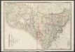
Netherlands
A new general atlas of modern geography, consisting of a complete collection of maps of the four quarters of the globe Wyld, James James Wyld
Circvlvs Bvrgvndicvs
1 : 732700 Belgie Mayer, Tobias Cassini de Thury Homannianis heredib.
Belgivm catholicvm seu Decem provinciae Germaniae inferioris
1 : 732700 Belgie Mayer, Tobias Cassini de Thury Homannianis heredib.
Netherlands.
1 : 1650000 Bowen, Frances
Holland, Belgien, Luxemburg.
1 : 1350000 Radefeld, Carl Christian Franz, 1788-1874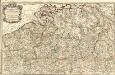
Carte Particuliere des Duchéz de Brabant et de Limbourg
1 : 317000 Mollova mapová sbírka Baillieul, Gaspard Bailleul, Gaspard
Carte des Pais Bas Catholiqves ou des X Provinces de l'Allemagne Inferieure etc. dessinée au juste selon les exactes observations Astronimiques et Operations Geometriques des Mess. Cassini. Snelius. Muschenbrok etc. dresée par Sr. Tobias Maier. Mathematicien
1 : 725000 Mollova mapová sbírka Mayer, Tobias Homann, Johann Baptista - dědici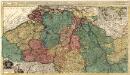
Novissima et Accuratissima decem Austriacarum in Belgio Provinciarum Tabula
1 : 600000 Mollova mapová sbírka Ottens, Joachim
Belgien, Luxemburg.
1 : 1000000 Andree, Richard
Carte des Paysbas Catholiques
1 : 700000 Mollova mapová sbírka Delisle, Guillaume L'Isle, Guillaume de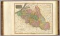
Belgium.
1 : 820000 Thomson, John
Carte physique et routière de la Belgique et de ses pans limitrophes
1 : 588000 Vuillemin, Alexandre Aimé 1812-1880 Paris : J. Langlumé et Peltier
Netherlands.
1 : 1350000 Arrowsmith, Aaron; Lewis, Samuel