Maps of Feltre

[Feltre]
1 : 61538 Feltre (Itálie)
Tomba Nordhälfte
1 : 25000 Benátsko (Itálie) 6. A.K.
Quero
1 : 10000 Benátsko (Itálie) Kriegsvermessung No. 13.
Tyrolis sub Felici Regimine Mariae Theresiae Rom. Imper. Avg. Chorographice Delineata ...
1 : 104000 Mollova mapová sbírka Mansfeld, Johann Ernst Mansfeld, Johann Ernest
Tyrolis sub Felici Regimine Mariae Theresiae Rom. Imper. Avg. Chorographice Delineata ...
1 : 104000 Mollova mapová sbírka Mansfeld, Johann Ernst Mansfeld, Johann Ernest
M. Spinuccia
1 : 10000 Benátsko (Itálie) Kriegsvermessung No. 13.
Cismon
1 : 25000 Benátsko (Itálie) Istituto geografico militare
S. Pietro di Barbozza
1 : 10000 Benátsko (Itálie) Istituto geografico militare
Il Trevisiano diviso ne suoi territori e distretti di nuova projezione
1 : 228000 Treviso (Itálie) Pitteri, Marco Alvise Antonio Zatta
Il Cadorino
1 : 280000 Mollova mapová sbírka Magini, Giovanni Antonio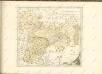

Belluno und Feltre.
from Spezialkarte der osterreichisch-ungarischen Monarchie.
Territorio Trevigiano
Mollova mapová sbírka Magini, Giovanni Antonio Magini, Fabio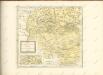

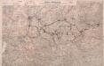
Italy: Trentino Orientale
Trentino Orientale: Enemy's organisation affecting British front. May 1918. From a collection of maps of the theatre of war in Italy, 1917-18. War Office
Borgo und Fiera Di Primiero.
from Spezialkarte der osterreichisch-ungarischen Monarchie.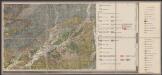
Geologische Übersichtskarte des tirolisch-venetianischen Hochlandes zwischen Etsch und Piave
1 : 75000 Südost-Blatt Mojsisovics, Edmund von Hölder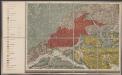
Geologische Übersichtskarte des tirolisch-venetianischen Hochlandes zwischen Etsch und Piave
1 : 75000 Südwest-Blatt Mojsisovics, Edmund von Hölder
Zone 21, Col. V, Borgo und Fiera di Primiero, uit: Geologische Karte der im Reichsrathe vertretenen Königreiche und Länder der Österreich-Ungarischen Monarchie : auf Grundlage der Specialkarte i.M. 1:75.000 des k.u.k. Militär-geographischen Institutes / neu bearb. und als Kartenwerk von 341 Blattnummern in zwanglosen Lfg. hrsg. durch die k.k. Geologische Reichsanstalt in Wien
1 : 75000 titelvariant: Geologische Spezialkarte der im Reichsrate vertretenen Königreiche und Länder der Österreichisch-Ungarischen Monarchie; Geologische Specialkarte der im Reichsrathe vertretenen Königreiche und Länder der Österreichisch-Ungarischen Monarchie; Annotatie: Titel bovenaan kaartblad: Geologische Spezialkarte der im Reichsrate vertretenen Königreiche und Länder der Österreichisch-Ungarischen Monarchie en Geologische Specialkarte der im Reichsrathe vertretenen Königreiche und Länder der Österreichisch-Ungarischen Monarchie; Annotatie geografische gegevens: Coördinaten gebaseerd op nulmeridiaan van Ferro (Hierro) Kaiserlich-Königliche Geologische Reichsanstalt, Wenen Wien : K.K. Geologische Reichsanstalt
IL | BELLVNESE | Con il | FELTRINO.
[Amsterdam : Joan Blaeu]

TERRITORIO | TREVIGIANO.
[Amsterdam : Joan Blaeu]
Territorivm Vicentinvm
1 : 270000 Vicenza (Itálie : provincie) Hondius, Henricus sumptibus Henrici Hondii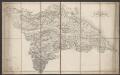
Il Bellunese Con il Feltrino [Karte], in: Le théâtre du monde, ou, Nouvel atlas contenant les chartes et descriptions de tous les païs de la terre, Bd. 3, S. 144.
1 Karte aus Atlas Blaeu, Willem Janszoon und Blaeu, Joan Blaeu, Willem Janszoon
Il Bellunese Con il Feltrino [Karte], in: Theatrum orbis terrarum, sive, Atlas novus, Bd. 3, S. 122.
1 Karte aus Atlas Blaeu, Joan Blaeu, Willem Janszoon
Il Cadorino [Karte], in: Novus atlas absolutissimus, Bd. 5, S. 33.
1 Karte aus Atlas Janssonius Offizin
Il Bellunese Con il Feltrino [Karte], in: Novus Atlas, das ist, Weltbeschreibung, Bd. 3, S. 142.
1 Karte aus Atlas Blaeu, Joan Blaeu, Willem Janszoon
TERRITORIO | DI | VICENZA
[Amsterdam : Joan Blaeu]
![[Feltre]](https://images-2.georeferencer.com/images/iiif/967566206251/full/,300/0/native.jpg)

