Maps of Arsiè

Cismon
1 : 25000 Benátsko (Itálie) Istituto geografico militare
Theatre of War in Italy
1 : 25000 From a collection of maps of the theatre of war in Italy, 1917-18. War Office
Tomba Nordhälfte
1 : 25000 Benátsko (Itálie) 6. A.K.
M. Spinuccia
1 : 10000 Benátsko (Itálie) Kriegsvermessung No. 13.
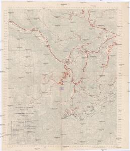
Italy: Trentino Orientale
Trentino Orientale: Enemy's organisation affecting British front. May 1918. From a collection of maps of the theatre of war in Italy, 1917-18. War Office
Territorio Trevigiano
Mollova mapová sbírka Magini, Giovanni Antonio Magini, Fabio
Territorio di Vicenza
1 : 330000 Mollova mapová sbírka Magini, Fabio Magini, Fabio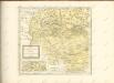

Diocesi Padovana con tutta la sua Estensione ne Vicini Territori
1 : 150000 Mollova mapová sbírka Clarici, Paolo Bartolommeo
La Territoire de Vicenza Ou sont marquées toutes les Vallees Cols, Passages et Mines d'Argent. Qui sont dans les Montagnes qui separent ce Pays de Léveché de Trente
1 : 370000 Mollova mapová sbírka Nolin, Jean-Baptiste Nolin, Jean Baptiste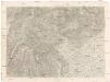
[Rivereto, Vicenza und Umgebung]
1 : 75000 K. u. k. Militärgeographisches Institut
Il Vicentino Diviso ne suoi Vicariati

Borgo und Fiera Di Primiero.
from Spezialkarte der osterreichisch-ungarischen Monarchie.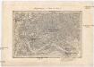
Umgebungen Trient und Salurn
1 : 144000 David, Johann K. u. k. Militärgeographisches Institut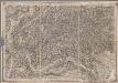
[Triënt, Borgo] / Joh. David sculp. ; C. Stein scrip.
1 : 144000 Annotatie: Linksboven: No. 20 David, Joh.; Stein, C. [S.l. : s.n.]
[Feltre]
1 : 61538 Feltre (Itálie)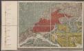
Geologische Übersichtskarte des tirolisch-venetianischen Hochlandes zwischen Etsch und Piave
1 : 75000 Südwest-Blatt Mojsisovics, Edmund von Hölder
Zone 21, Col. V, Borgo und Fiera di Primiero, uit: Geologische Karte der im Reichsrathe vertretenen Königreiche und Länder der Österreich-Ungarischen Monarchie : auf Grundlage der Specialkarte i.M. 1:75.000 des k.u.k. Militär-geographischen Institutes / neu bearb. und als Kartenwerk von 341 Blattnummern in zwanglosen Lfg. hrsg. durch die k.k. Geologische Reichsanstalt in Wien
1 : 75000 titelvariant: Geologische Spezialkarte der im Reichsrate vertretenen Königreiche und Länder der Österreichisch-Ungarischen Monarchie; Geologische Specialkarte der im Reichsrathe vertretenen Königreiche und Länder der Österreichisch-Ungarischen Monarchie; Annotatie: Titel bovenaan kaartblad: Geologische Spezialkarte der im Reichsrate vertretenen Königreiche und Länder der Österreichisch-Ungarischen Monarchie en Geologische Specialkarte der im Reichsrathe vertretenen Königreiche und Länder der Österreichisch-Ungarischen Monarchie; Annotatie geografische gegevens: Coördinaten gebaseerd op nulmeridiaan van Ferro (Hierro) Kaiserlich-Königliche Geologische Reichsanstalt, Wenen Wien : K.K. Geologische Reichsanstalt
Tomba Südhälfte
1 : 25000 Benátsko (Itálie) Kriegsvermessung 13.
Carta del dipartimento del Bacchiglione
1 : 156000 Biasioli, A.
Carta del dipartimento del Bacchiglione
1 : 160000 Rouvre, F. Richard de Lanzani, K. Giuseppe Giuliani
IL | BELLVNESE | Con il | FELTRINO.
[Amsterdam : Joan Blaeu]

TERRITORIO | TREVIGIANO.
[Amsterdam : Joan Blaeu]
Territorivm Vicentinvm
1 : 270000 Vicenza (Itálie : provincie) Hondius, Henricus sumptibus Henrici Hondii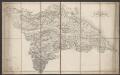
Il Bellunese Con il Feltrino [Karte], in: Le théâtre du monde, ou, Nouvel atlas contenant les chartes et descriptions de tous les païs de la terre, Bd. 3, S. 144.
1 Karte aus Atlas Blaeu, Willem Janszoon und Blaeu, Joan Blaeu, Willem Janszoon
Il Bellunese Con il Feltrino [Karte], in: Theatrum orbis terrarum, sive, Atlas novus, Bd. 3, S. 122.
1 Karte aus Atlas Blaeu, Joan Blaeu, Willem Janszoon
Il Bellunese Con il Feltrino [Karte], in: Novus Atlas, das ist, Weltbeschreibung, Bd. 3, S. 142.
1 Karte aus Atlas Blaeu, Joan Blaeu, Willem Janszoon
TERRITORIO | DI | VICENZA
[Amsterdam : Joan Blaeu]