Maps of New Town

Plan von Prag und den Vororten
1 : 14400 Praha (Česko)
Plán Prahy s okolím
1 : 10000 Praha (Česko) Hurtig, Alfred Alfred Hurtig
Plán Prahy s okolím
1 : 10000 Praha (Česko) Hurtig, Alfred Alfred Hurtig
Plán Prahy s okolím
Praha (Česko) Hurtig, Alfred Mikolášek, Antonín Alfred Hurtig
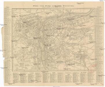
Neuester Haase'scher Plan von Prag und der nächsten Umgebung
1 : 11725 Praha (Česko) A. Haase
Nejnovější Haasovský plán Prahy s nejbližším okolím
Praha (Česko) Routa, F. Grefnetter, Josef A. Haase
Plán Prahy I-VII
1 : 10000 Praha (Česko) Hurtig, Alfred Marek, V. Alfred Hurtig
Situations-Plan der königlichen Hauptstadt Prag
Praha (Česko) Loth, Johann Anděl, Bedřich Fiedrich Kretzschmar
Bez titulu: Polohopisný plán královského hlavního města Prahy
Pharusův plán hlav. města Prahy
1 : 14000 Praha (Česko) Löwe, Cornelius K. André
Pan von Prag und der nächsten Umgebung
1 : 11520 Praha (Česko) Strnad, Josef Bohemia
Nejnovější a nejúplnější plán královského hlav. města Prahy, Karlína, Žižkova, Královských Vinohradů, Vršovic, Nuslí, Smíchova a nejbližšího okolí
1 : 12000 Karlín (Praha, Česko) Brož, Josef A. Storch syn
Plán hlavního města Prahy

Plan von Prag und Umgebung 1874
1 : 14600 Praha (Česko) Kořistka, Karel František Edvard Verlag der statistichsen Kommission der königl. Haupstadt Prag
Plán kr. hl. města Prahy s vůkolím 1874
1 : 14600 Praha (Česko) Kořistka, Karel František Edvard náklad statistické kommisse kr. hl. m. Prahy
Plán kr. hl. města Prahy s vůkolím 1874
1 : 14600 Praha (Česko : oblast) Kořistka, Karel František Edvard Statistická kommisse
Plan von Prag und Umgebung 1874
1 : 15000 Praha (Česko : oblast) Kořistka, Karel František Edvard Statistische Kommission
Plán hlavního města Prahy
1 : 10000
Neuester Plan von Prag mit seiner Umgebungen
1 : 18000 Praha (Česko) bei Gottl. Haase Söhne
Plán Prahy z roku 1791
1 : 3456
Plánek hlavního města Prahy

Praha autoplán
Praha, hlavní město ČSR : Fastrův obrázkový plán a průvodce
1 : 10000
Prager Stadtplan

Nejnovější plán král. hlav. města Prahy a předměstí
1 : 10000 Praha (Česko) Hurtig, Alfred Schraembl, Franz Anton V. K. K. V.
Plán Prahy, Karlína, Smíchova, Vyšehradu, Žižkova, Král. Vinohradů a nejbližšího okolí
1 : 20000 Praha (Česko) Brož, Josef Šimáček, Josef A. Felkl
[Plán Prahy a předměstí]
Praha (Česko) Wagner, Jan Eduard
Erinnerung an Prag: Beschreibung der hauptsächlichsten Merkwürdigkeiten dieser Hauptstadt

Kriegs-Expeditions-Karte in Böhmen I. Blat, in welchem die Haubtstadt Prag mit der französsischen und saechsischen Belageru[n]g und Eroberung, so den 26. Novembre 1741. geschehen, vorgestellet wird
1 : 20700 Praha (Česko) Meyer Sinsart von Homaen[n] Erben