Maps of Košíře

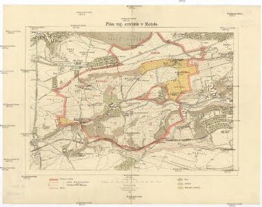
Plán voj. cvičiště v Motole
1 : 10000 Motol (Praha, Česko) Vojenský zeměpisný ústav
Croquis zur schriftlichen Ausarbeitung
1 : 13500 Bílá Hora (Praha, Česko)
Výškopisný plán hlavního města Prahy s okolím

Orientační plán hlavního města Prahy s okolím
1 : 5000
Orientační plán hlavního města Prahy s okolím

Orientační plán Prahy a obcí sousedních List 14.

Mottol - c4858-1-003 - Kaiserpflichtexemplar der Landkarten des stabilen Katasters
1 : 2880
Mottol - c4858-1-001 - Kaiserpflichtexemplar der Landkarten des stabilen Katasters
1 : 2880
Mottol - c4858-1-002 - Kaiserpflichtexemplar der Landkarten des stabilen Katasters
1 : 2880
Orientační plán král. Hl. města Prahy

Koschirz (Kossirz) - c3401-1-001 - Kaiserpflichtexemplar der Landkarten des stabilen Katasters
1 : 2880
Koschirz (Kossirz) - c3401-1-002 - Kaiserpflichtexemplar der Landkarten des stabilen Katasters
1 : 2880
Smíchov
1 : 5760
Smíchov
[Smíchov a Košíře]
Košíře (Praha, Česko)
Plán výstavy
Košíře (Praha, Česko) Schulz, R. A. Medau, Karel Vilém
Gross Brzewnow (Welky Břewnow) - c0558-1-001 - Kaiserpflichtexemplar der Landkarten des stabilen Katasters
1 : 2880
Gross Brzewnow (Welky Břewnow) - c0558-1-002 - Kaiserpflichtexemplar der Landkarten des stabilen Katasters
1 : 2880
Gross Brzewnow (Welky Břewnow) - c0558-1-003 - Kaiserpflichtexemplar der Landkarten des stabilen Katasters
1 : 2880
Plán královského hlavního města Prahy 1815

Orientační plán hlavního města Prahy s okolím
1 : 5000
Orientační plán hlavního města Prahy s okolím

Orientační plán hlavního města Prahy s okolím

Výškopisný plán hlavního města Prahy s okolím

Orientační plán hlavního města Prahy s okolím
1 : 5000
Plan der Haupstadt Prag 11

Praha : orientační plán : Československá spartakiáda 1975
1 : 15000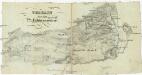
Terrain für das 2te Feldmanoeuvre
1 : 60000 Praha (Česko)
Smichow - c7068-1-001 - Kaiserpflichtexemplar der Landkarten des stabilen Katasters
1 : 2880
Smichow - c7068-1-005 - Kaiserpflichtexemplar der Landkarten des stabilen Katasters
1 : 2880
Smichow - c7068-1-003 - Kaiserpflichtexemplar der Landkarten des stabilen Katasters
1 : 2880
Smichow - c7068-1-002 - Kaiserpflichtexemplar der Landkarten des stabilen Katasters
1 : 2880